Monthly Archives: September 2021

Dark Sky

Sunset at Headlands International Dark Sky Park

We left northern Lower Michigan this morning. We’re spending the night at a Harvest Host, Frontière Farm House, in Marshall, 13 miles east of the home of the Kellogg Company, Battle Creek. Tomorrow we head to Indianapolis to visit an old friend of Michael’s. I’m sad to leave the Great Lakes behind.

We spent last night star gazing at the Headlands International Dark Sky Park in Mackinaw City. The Headlands Park has 550 acres of woodlands on more than two miles of undeveloped Lake Michigan shoreline. In 2011, the Headlands became one of the first International Dark Sky Parks in the world. In 2007, Natural Bridges National Monument in Utah became the first designated Dark Sky Park; Today, there are over 180 in the world.

I had never heard of a Dark Sky Park. So, what is it? It’s a park or other public land with exceptional starry skies, where natural darkness is valued as a natural resource. To get the designation, a park has to be accepted and certified by the International Dark Sky Association (IDSA) after a rigorous application process. Founded in 2001, the goal of the IDSA is to encourage communities to preserve and protect the night sky. It’s the leading organization combating light pollution worldwide.

From the Park’s entrance you drive down a dark, wooded, winding road to the parking lot. The road is narrow and you have to maneuver a little to allow an oncoming car to get by. From the parking lot there’s a long path lit by red lights leading to the observation area at the shoreline. The area is laid out in front of the Waterfront Event Center. The Center has several rows of long steps facing the lake. The steps form a kind of stadium seating. Many of the folks there were sitting on the steps.

At the head of the path is a list of rules: No flashlights, no cell phone use, no flash photography – white light pollutes the sky. And no laser pointers. Of course, not everybody respected the rules; so annoying.

We got to the Headlands at about 8pm dressed for the weather with a couple of lap quilts (made by me) for extra warmth. It was a mild, calm night, but the temperature at the lake is about 10 degrees colder than the inland temp. There was not a cloud in the sky. The sun had set, but the horizon was still glowing with the sun’s final rays. The sky was starless. We set up our chairs and along with about 60 other folks, waited.

And then the stars gradually made their appearance. A couple of folks had fancy looking cameras set up on tripods – clearly they were very serious about their star gazing. As an especially bright “star” made its appearance someone in the crowd declared that it was the International Space Station. Other folks were pointing out constellations. We saw a couple of shooting stars. I wish I had studied up on the night sky, but the only thing I recognized was the Big Dipper and the Milky Way. The sky was blanketed with stars by the time we left.

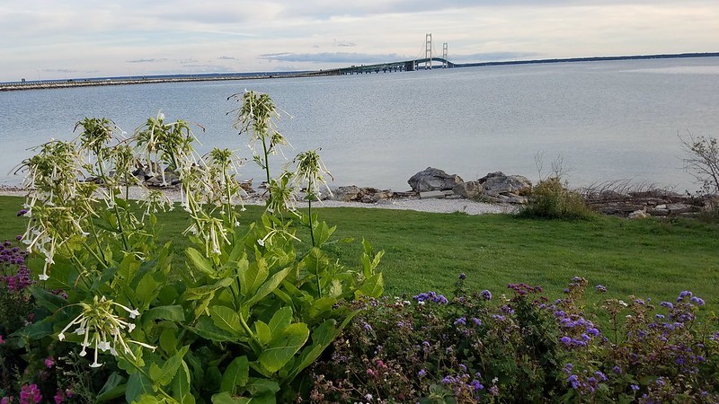
This morning before heading out, I took a final walk to the shore behind the RV to say goodbye to Lake Huron, the Mackinac Bridge and our Great Lakes tour.

The bench behind our campsite. My place to sit and take in Lake Huron
A final look at the Mackinac Bridge in the distance.

i thank You God for most this amazing day

Lake Huron at Sunrise

We’re sitting by the Lake Huron shoreline on a cool but sunny fall afternoon. The Mackinaw Bridge is in the distance; we watch as the cars and trucks seem to crawl over it. The small waves lap the shore. It is soooo peaceful here. It’s a blessing to be here today.

This morning we took a ride down to Cheboygan, a small coastal town a few miles from here. After lunch at a park overlooking the bay, we did a quick shopping run. We got back to the RV, put the groceries away and wondered what to do next. Both of us decided to just stay here at the campground, enjoying the moment.

This is our last day here and our last day visiting the Great Lakes. Tomorrow we head toward Indianapolis. We will miss this beautiful place.

Sunrise over Lake Huron

Lake Superior

Monday was the big day – we met our fifth Great Lake, Lake Superior. Lake Superior is the northern border of the UP. It is the largest and northernmost Great Lake. It holds 10% of the world’s fresh water supply. (The Great Lakes in total hold 18-20%). Most of it lies in Canada. It’s Canada’s largest lake.

Getting to Lake Superior from Mackinaw City requires driving over the Mackinac Bridge, across the eastern part of the UP to Whitefish Bay. As you drive over the bridge you get a clear view of both sides of the water – Lake Michigan to the left and Lake Huron to the right. Someone we know who is native to Michigan suggested one of us drives one way and the other drives back. It was a great suggestion; it allowed each of us to fully take in the Lakes. I drove on the way up.

When you get to the Upper Peninsula you quickly notice how different the landscape is from lower Michigan. Lots of trees with no farmland. We stopped in the village of Trout Lake at what looked like a convenience store, an IGA grocery store as it turns out, for a bathroom break. I tried to engage the store clerk (an older woman, maybe the owner) in conversation as I paid for my Coke, but I didn’t get much from her. I figured she was just a taciturn sort, until a man came in, clearly a local, and she greeted him warmly. Maybe it was my face mask, maybe being an outsider, either way she was not interested in talking with me. Very different experience from my interactions with other Michiganians, who have all been cheerful, warm and helpful.

Outside the IGA. You won’t find this outside most grocery stores.

It was about a little over an hour’s drive to get across the UP to White Fish Bay at the eastern end of Lake Superior. There you find The Great Lakes Shipwreck Museum, located at the Whitefish Point Light-Station.

We made it! Lake Superior.

The Michigan Shipwreck Research Association estimates there are more than 6,000 shipwrecks at the bottom of the Great Lakes since the late 1600s when commercial sailing ships began crossing the Lakes. Unpredictable weather with fierce and sudden storms and lots of fog made for dangerous crossings.

The SS Edmund Fitzgerald is the largest ship sunk in the Great Lakes. It carried iron ore from Minnesota to several Great Lake ports. It was considered a “workhorse”, setting record hauls, 6 trips in one season. The ship was lost on November 10, 1975, with 29 crew members on board. That last thing heard from it was the captain reporting, “We are holding our own.” No distress signal was sent.

A memorial to the Edmund Fitzgerald sits at the top of the beach at Whitefish Bay. The shipwreck is memorialized in the song by Gordon Lightfoot, “The Wreck of the Edmund Fitzgerald”

“The legend lives on from the Chippewa on down
Of the big lake they called Gitche Gumee
The lake, it is said, never gives up her dead
When the skies of November turn gloomy.

And later that night when his lights went outta sight
Came the wreck of the Edmund Fitzgerald.”

Next stop was Tahquemenon (rhymes with phenomenon) Falls State Park. The Falls are one the largest waterfalls east of the Mississippi. The Upper and Lower falls combine for a drop of nearly 73 feet and it’s more than 200 feet across. The water is brownish in color leading some to wonder if it’s polluted. It’s not. The color comes from tannins leached from the cedar swamps along the Tahquemenon River. One of its nicknames is “the Root Beer Falls”.

You can get a good view of the Upper Falls. A nicely paved path about a quarter mile from the parking lot leads you to good vantage points. 94 steps take you down close to the Falls. Michael ventured down. I sat and admired the rushing water.

Tahquemenon Upper Falls

On our way back we stopped at several places to get a closer look at the Mackinac Bridge, both “above the bridge” (the UP side) and back in Mackinaw City. One of the parks we stopped at had a tribute to David Steinman, the designer of the Bridge. He believed bridges should be beautiful. He even wrote poems about bridges; “A bridge is a poem stretched across a river, a symphony of stone and steel”. He designed the Mount Hope Bridge spanning the Narragansett Bay from Bristol to Newport, RI.

The Mackinac region

We arrived in Mackinaw City on Sunday (9/26). We’re staying at Mackinaw Mill Creek Camping. The campground has over 200 acres of woods and a mile of Lake Huron shoreline with a view of the Straits of Mackinac and the Mackinac Bridge. It is an impressive campground, probably the biggest we’ve stayed at. As I write this, I’m sitting about 12 feet from the waters of Lake Huron, with a clear view of the Bridge. It’s 57°, breezy but sunny. I would never sit outside at this temperature back home. But with Nature’s awesomeness spread out before me, who cares about a little nippiness.

The view from the RV

I never thought much about the state of Michigan. I could have pointed it out on a map only because of its proximity to Canada. And I didn’t think of it as a state worth visiting. It’s a Midwestern state and I must confess, as a lifelong resident of the land of the coastal elites, I have an unfavorable bias towards the Midwest. Remember how last year an anti-government group called the Michigan Militia plotted to kidnap the governor, Gretchen Whitmer, and incite a civil war over Covid restrictions? Sheesh, why would I want to visit a state as crazy as that? Well, one of the benefits of travel is having your biases challenged.

When we planned this current trip our focus was the Great Lakes. Since Michigan is bordered by 4 of the 5 Great Lakes (only Lake Ontario misses Michigan) there’s no way to explore the US Great Lakes without spending time in Michigan. So we find ourselves in Michigan for close to a month. And what a breathtakingly gorgeous state it’s turned out to be. Fun Fact: No point in Michigan is more than 85 miles from any one of the Great Lakes.

Mackinaw City is at the northern tip of Michigan’s Lower Peninsula along the southern shore of the Straits of Mackinac. Time for a quick geography lesson.

A picture is worth 1000 words

The state of Michigan is made up of two peninsulas, what’s referred to as the Lower Peninsula and the Upper Peninsula. The Lower Peninsula is shaped like a mitten. It’s mostly flat and a distinctive feature is the “Thumb” jutting out into Lake Huron, creating Saginaw Bay. The Upper Peninsula is mostly forested, reaches higher elevations and has rugged terrain.

The Upper Peninsula, referred to as the U.P., shares a border with Wisconsin and a bit of Minnesota. It’s physically separated from the Lower Peninsula. The UP is about 30% of the land mass of Michigan. The peninsula is as large as Connecticut, Delaware, Massachusetts, and Rhode Island combined, but has fewer than 330,000 inhabitants, referred to as “Yoopers”.

Short waterways between the peninsulas are called the Straits of Mackinac and connect Lakes Michigan and Huron. As early as 1920, suggestions to bridge the 2 peninsulas were kicked around, ranging from building a “floating” tunnel to building various combinations of bridges and causeways. The state settled on establishing a ferry service. Then in the 1950s a major bridge was proposed. And on June 28, 1958 the Mackinac Bridge, the Mighty Mac, was formally dedicated.

The Mackinac Bridge is currently the fifth longest suspension bridge in the western hemisphere. Longer than the Golden Gate Bridge, you may ask? Yes! The Golden Gate is the oldest suspension bridge, it’s taller than the Mackinac Bridge, it’s also wider and carries more traffic. But it’s only 1.7 miles long; the Mackinac is 5 miles long. And to add to its awesomeness, the Mighty Mac straddles Lakes Huron and Michigan. The Golden Gate Bridge straddles a puny mile wide stretch of water called the Golden Gate Strait. Ok, the Golden Gate offers views of San Francisco Bay and the Pacific Ocean, but the Mackinac is still down right impressive. And it’s not shrouded in fog (or wildfire smoke).

A word about pronunciation. You may have already noticed that some things are spelled “Mackinaw”, others “Mackinac”. Regardless of spelling it’s all pronounced Mack-i-naw. The Anishinaabek people named this area Michinnimakinong, an Ojibwa word which translates as ‘“great connecting sound fault land or place”. The Anishinaabek made their home in this area. They were a group of culturally related indigenous people consisting of 7 clans, of which one was the Ojibwa. The Mackinac Island in Lake Huron was called Mitchimakinak, “the place of the great turtle”; the indigenous settlers thought the island looked like a big turtle.

The first Europeans to arrive in Michigan were the French. The French were traders and traded with the Indigenous peoples. The French translated the local language into something more fitting to their own language and recorded the place names with a “c” on the end as a French word with an “aw” sound would be pronounced. But the French lost the French and Indian War to the British and everything became anglicized.

The UP is bordered on the north by Lake Superior. The Ojibwa name for the lake was “gichi-gami”, meaning “great sea”. The French called it “le lac supérieur”. And when the British beat the French they called it Lake Superior, “on account of its being superior in magnitude to any of the lakes on that vast continent”.

Next up: our trek over the Mackinac Bridge, across the eastern part of the Upper Peninsula to Whitefish Bay and Lake Superior.

Good bye Traverse City

Tomorrow we leave Traverse City. We’ve enjoyed our stay here in this beautiful area.

Yesterday we took a bike ride on a section of the TART (Traverse Area Recreation Trail). It’s a nicely maintained bike path that follows the old railroad bed of the former Chicago and West Michigan Railway. We had parked the car at the Cherry Bend Community Park. The Park has a pavilion with several picnic tables. After our ride we found a sunny spot at one of the tables-it was a little too cool in the shade-and had our lunch. We always take a “brown bag” lunch with us.

After lunch we drove the 18 miles on M-37 to the tip of Old Mission Peninsula, the finger of land that heads north from downtown Traverse City to Grand Traverse Bay. The peninsula is about 3 miles wide. The drive takes you by cherry orchards and vineyards. Lighthouse Park is at the tip of the peninsula. The Park has a restored turn of the century log cabin (it reminded me of Little House on the Prairie), hiking trails, a pretty beach and, of course, the Old Mission Lighthouse. The lighthouse has a small museum with exhibits all about lighthouses.  Fun Fact: the Boston Light in Boston Harbor is the oldest continually used and only staffed lighthouse in the country.

On our way back we stopped at the Bonobo Winery; there are 10 wineries on the peninsula. We each got a glass of wine and sat on the big, very pretty deck overlooking the vineyard with the Bay in the distance.

Bonobo Vineyards

Today we went to the Dennos Museum on the campus of Northwestern Michigan College in Traverse City. The Museum has a permanent exhibit of the art of the Inuit of the Canadian Arctic.  It’s one of the most historically complete collections of Inuit sculptures and prints available. So much of the art was about the natural world. I’m guessing that speaks to the Indigenous peoples’ connection to nature.

The museum was also showing an exhibit called “AWAY FROM HOME: American Indian Boarding School Stories”. It told the heartbreaking story of the US government’s efforts, starting in the 1870s, to educate and assimilate Native Americans into ‘civilized’ society by establishing residential schools.

Thousands of Native children from hundreds of tribes were oftentimes forcibly taken from their families and placed in distant boarding schools. Many of the children went years without seeing their families. Most would travel for weeks by wagon, train and steamboat. On arrival, they were stripped of their clothes, made to wear Victorian-style or military uniforms, their hair was cut and they were forbidden to use their own language. Part of their ‘processing’ was to have before and after photographs taken.

The schools provided a limited academic education primarily focusing on teaching practical skills in construction, farming, raising livestock, domestic skills like laundry, sewing and cooking. The students were then forced to work in the local community. It was a boon to the white communities, supplying a work force to fuel their economies.

Another moving exhibit was named “BIRDS FLY IN: A Human Refuge”, what the artist Ellie Harold called a collaborative art project. The introduction explains that the artist applied black pigment directly to the canvas “in an attempt to resolve her strong emotions” following the 2016 presidential election. Over time, the shapes she created “revealed themselves to her as birds” and she came to understand them as “intuitive messengers of hope and healing for a troubled world”. Harold collaborated with a Mexican composer to create a soundtrack for the exhibit, a German architect to design the structure, while her British husband provided first hand experience of the immigration process.  She also collaborated with several other artists and poets and had everything translated into Spanish by a faculty member at Northwestern Michigan College.

The result was a chain link “cage” that filled the room. Worn shoes in various sizes, some single shoes, others in pairs, hang off the links. You’re invited to walk around the enclosure, reading the poetry, printed in English and Spanish, posted around the perimeter. Evocative, instrumental music plays in the background. A sitting area is placed in the center of the “cage”. Several large canvases of Harold’s “bird” scenes hang on the inside of the cage. She describes the paintings as being created by “intuitive marks”.

A printed card offers instructions for “Finding and Minding the In-Side”. After taking a seat you’re invited to “engage the Art and Music by quietly looking, listening, contemplating and responding.” Harold suggests you pick one painting and spend at least 5 minutes looking, then offers prompts to aid in processing the art. The final suggestion is to “Respond Intuitively” and jot down or draw your impressions on the back of the card.

I intended to write just a couple of words. Instead, I was moved to write a couple of paragraphs that turned out to be more of a poem, and I am not a poet. But the paintings, poetry and music combined with the experience of seeing and sitting in the cage were so evocative, the words just rose to the surface. It was definitely the most moving experience I’ve ever had with a work of art.

After a stop in the museum store we headed to downtown for lunch. We ate at a place called “Little Fleet”, a restaurant made up of several fixed food trucks set up along the perimeter of an enclosed parking lot, with outdoor seating and an indoor bar. An outdoor food court! Only with good food. The restaurant was across the street from one of the entry points to the Boardman River, which flows through the city. We took the steps down to the river’s edge.

We wrapped up our outing with a drive up M-22, along the eastern side of Leelanau Peninsula to Suttons Bay, a beach town on Grand Traverse Bay. If you continue on M-22 around the tip you end up at Sleeping Bear Dunes National Lakeshore. As with any drive along these shores, there were more picturesque scenes than you can actually take in.

Pierce Stocking Drive

We’ve been on a few scenic drives in our travels. They’re a great way to get an overview of an area’s natural offerings. Due to the varied and interesting terrain of this part of Michigan and the passion of the man for whom the drive is named, Pierce Stocking Drive is by far the best scenic drive we’ve taken.

Pierce Stocking was born in 1908, in northern Lower Michigan. He worked as a lumberman and part of his job was to build roads in difficult terrain. He loved the woods and developed a self-taught knowledge of nature. He walked the bluffs above Lake Michigan, awed by the views of the dunes, Lake Michigan and the Manitou islands. He wanted to share this beauty with others and conceived the idea of a road to the top of the dunes.

He planned the route and built the road himself. In 1967, the road, then known as the Sleeping Bear Park, first opened to the public. Stocking operated the scenic drive until his death in 1976, charging $2 per car (equivalent to $9.10 in 2020). In 1977, the road became part of Sleeping Bear Dunes National Lakeshore. Several years later, based on public opinion, the drive was named the Pierce Stocking Scenic Drive.

The drive is 7.4 miles long, with 12 stops along the way. In addition to the usual educational signs at each stop, a booklet, published by the Friends of Sleeping Bear Dunes, offers a good overview, with lots of information, as you drive along the route.

The drive starts off through deciduous forest of mainly maple and beech trees. The first stop is a covered bridge. If you’ve ever wondered, as we did, why bridges were covered, they were developed to protect the wooden bridges from rain and snow.

Stop #2 offers a view of Little Glen Lake and the narrows that separate Little Glen from Big Glen Lake. Glen Lake was once connected to ancestral Lake Michigan. It’s one of 20 inland lakes within the Sleeping Bear Lakeshore.

At Stop #3 you get a view of “perched” dunes, referred to as perched because they sit atop bluffs made of sand and gravel. The stop gives you a good sense of the vegetation that grows in such a harsh environment. Stop #4 gives hiking-able folks a chance to hike a 1.5 mile loop through the dunes and a close up view of the dune ecosystem. For those of us who are hiking-challenged, we get to see the cottonwood trees and learn about its important role in dune ecology.

The cottonwood tree is fast growing. It can reproduce by sprouting new trunks from its roots, referred to as cloning, creating clusters of trees that stabilize the dune. A stabilized dune allows for other vegetation to take hold – plant life that couldn’t survive on an active dune.

At Stop #5 we learn about dune ecology – how dunes are formed, how they move over time and create ghost forests – trees that fell victim to the sand build up as the dunes were forming leaving behind skeleton trees – and finally stabilized dunes with it’s own kinds of vegetation.

The drive continues through maple-beech forest. Such a contrast to the wide vistas of the dunes and lakes. And then we arrive at Stop #9-10, the Lake Michigan Overlook. Wow! Definitely occasion for a blessing: Baruch ata Adonai, ruach ha’olam, oseh ma’aseh v’rei’sheet/Blessed are you Spirit of the world, Source of creation.

I got to do my own mini Dune Cimb, as the sand blowing up the bluff and to the east deposits sand on the walkway creating a slightly inclined “dune” that even I can manage. The walkway leads to the edge of the bluff that drops off 450 ft to Lake Michigan. And there’s a great observation deck that gives you a sweeping view of Lake Michigan, the Manitou islands and the dunes. Words can’t describe the awesomeness of the nature that lies before you (in the true sense of awe).

It’s tempting for some folks to hike down to the shore, but a posted sign clearly cautions “Enjoy the view from here”. The rising water level has made beach-cart rescues impossible. The sign warns, “Lake levels are high – the only way out is up. Rescues cost $3000. Keep yourself and our rescuers out of danger.” Nonetheless, some brave (reckless?) souls ventured down. No one needed rescuing while we were there. But it happens. In 2014 there were 47 rescue operations to help 61 people. Plus, all the climbing over the years has eroded the bluff, so ‘enjoying the view from here’ limits the environmental impact of humans.

The forces of nature have their own impact on this beautiful land and lakescape. The ‘Mother Bear’ dune, once stood 234 ft high with a dense plant cover. By 1980 it was down to 103 ft. The wave and wind action is eroding the base on which the dune sits. It’s only a matter of time -one prediction is 30 years – before the ‘Mother Bear’ disappears completely. It’s already difficult to make out the the “Bear” from the observation deck.

The rest of the drive feels anti-climactic. Stop #11 is the North Bar Overlook. The North Bar Lake is a narrow lake separated from Lake Michigan. You have to look closely at the picture to notice the small lake dwarfed by the Great Lake. It’s great for swimming as it’s warmer than Lake Michigan. It has a beach that’s popular with families with young kids.

North Bar Lake with Lake Michigan behind it.

The last section of the drive – Stop #12 – takes you through a Pine Plantation, planted rows of pine trees. Property owners used to plant pine trees to prevent erosion, provide a wind break and yield timber lumber. But the plantations are out of place in Sleeping Bear Dunes National Lakeshore. As a national park, the mission is to preserve the natural environment, so native forest growth is desirable. The pines keep other vegetation from growing. Some portions of the pine plantations have been cut down to allow for natural vegetation to mix in with the remaining pines.

Thank you Mr. Pierce Stocking for this awesome trip through the wonders of Sleeping Bear Dunes National Lakeshore.

And since, in my estimation, you can never enjoy too many sunset pics, here’s my take on the sunset on Lake Michigan.

Sun setting on Lake Michigan

Cathie and Michael’s Excellent Day

Sleeping Bear Dunes National Lakeshore

OK, I’m sold. Michigan is a beautiful state with some incredible natural wonders. Today we spent most of the day at Sleeping Bear Dunes National Lakeshore. This gem is in the northwest corner of the lower peninsula. The park stretches 35 miles along Lake Michigan and contains forests, dunes, beaches, islands and remnants of ancient glacial activity. The name of the park comes from an Ojibwa legend. As described in a Wikipedia article:

According to the legend, an enormous forest fire on the western shore of Lake Michigan drove a mother bear and her two cubs into the lake for shelter, determined to reach the opposite shore. After many miles of swimming, the two cubs lagged behind. When the mother bear reached the shore, she waited on the top of a high bluff. The exhausted cubs drowned in the lake, but the mother bear stayed and waited in hopes that her cubs would finally appear. Impressed by the mother bear’s determination and faith, the Great Spirit created two islands (North and South Manitou islands) to commemorate the cubs, and the winds buried the sleeping bear under the sands of the dunes where she waits to this day.

One of the highlights of the park is the Dune Climb. It’s a 3.6 mile hike up several dunes, through the windblown sand. It’s not an easy hike but I was rewarded with spectacular views. Cathie stayed below while I explored the trail.

Today was a windy, autumn day. The waves reminded me of beaches on the Atlantic Ocean, complete with whitecaps. We originally planned to have lunch outdoors but decided to snack on our sandwiches in the car, due to the wind.

Lake Michigan at Glen Haven Historical Area

The park includes a 7.4 mile roadway through the varied terrain of the park. The drive was designed and built by Pierce Stocking, a lumberman who worked for the Civilian Conservation Corps before becoming a lumberman. He loved the beauty of the dunes so much that he wanted to share his love with others. The drive opened in 1967. After Pierce Stocking’s death in 1976, the roadway became part of the Sleeping Bear Dunes National Lakeshore. We spent over an hour driving and stopping at various points on the roadway, viewing stunning vistas.

Lake Michigan view from Pierce Stocking Drive

We ended our day in Frankfort, a cute town a bit south of the park, along the Lake Michigan coast. We decided to have dinner at a local restaurant so that we could view the sunset over the lake.

It was a good day.

Onto Lake Michigan

On Monday (9/20) we made our way to Traverse City. We’re staying at the Holiday Park RV Campground. It’s a lovely campground on the shore of Silver Lake in Traverse City. This is home for the next 6 nights.

Traverse City is in northwestern Michigan. It has a population of about 15,000. The city lies at the base of two bays, East Grand Traverse Bay and West Grand Traverse Bay, which flow into the Grand Traverse Bay which then empties into Lake Michigan. Separating the bays is a narrow peninsula heading north from Traverse City called Old Mission Peninsula. “La Grand Traverse” was the name given to this body of water by French traders because of the “long crossing” they had to make by canoe across the mouth of the bay.

After dinner we took a drive into town. We stopped at the waterfront with its marina. Then drove through the downtown area and made the obligatory stop at The Cherry Republic store which sells all things cherry; Traverse City is the cherry capital of the world. It looks like a charming city.

Tuesday was a rainy day. I didn’t mind though because it was a work day for Michael. I did laundry – we were overdue – paid some bills and did other odds and ends. Tomorrow we set out to start exploring.

Moonrise, Sunset

It’s hard to see a sunset over Lake Huron in Northern Michigan. The lake is on the eastern side of the state, so, sunrises but not sunsets. But Cathie found a place. We went to Rogers City today for dinner and a sunset view. The park where these pictures are taken is a small cove where we were able to see the sun set over the water. However we got a bonus treat with an ‘almost’ full moonrise as well. The pictures don’t do the scene justice.

Small town Michigan

We took a bike ride into Hillman today. The RV park where we’re staying, The Thunder Bay Golf and RV Resort (no, we don’t play golf and yes, it’s an odd combination) is in the town of Hillman, 23 miles west of Alpena. Hillman has a population of 638. It’s a one street town.

We can bike into town from the campsite. A bridge takes us over the Thunder Bay River, behind the elementary school and connects up with the Hillman Bike Path. Such a nice surprise to find that a tiny town has a bike path.

Alpena Miscellany

What does it say about a place that hangs art in its restrooms and decorates its stalls with inspirational quotes?

Ladies room at Besser Museum for Northeast Michigan

The Besser Museum, in addition to it’s natural history exhibits, had a small modern art gallery.

Segol Sher Shalosh by Yaacov Agam. Born n 1928 in then Mandate Palestine, studied at the Bezalel Academy in Jerusalem.

There’s an historically-oriented walking tour along the Thunder Bay River in downtown Alpena. The goal of the River Walk is to demonstrate the importance of Lake Huron and the Thunder Bay River in the development of Alpena and its unique maritime culture and to share its history.

Informational plaque on the Riverwalk about the Fire of 1888

There are several parks in Alpena on Huron Bay. All have beaches, some with playgrounds, some with picnic tables. We stopped at Mich-E-Ke-wis Park, named in honor of Chief Mich-E-Ke-Wis, one of the last Native American chiefs in the area. His name means “Spirit of the Western Wind”. He lived to be nearly 110 years old. He died in 1857

Northern Michigan

Traveling across the state of Michigan is very different from traveling across the state of Rhode Island. Michigan is the 22nd largest state in the US. It’s slightly smaller than all six New England states combined. You could fit Rhode Island into it 54 times and still have something left over. So, the climate in Michigan varies more than within each of the New England states. The other day we were in Bay City, about 120 miles south of our current location, near Alpena. The leaves were looking a bit washed out but hadn’t started turning yet. Here, some of the trees are starting to turn. Even though Friday was over 80 degrees, fall is coming.

On Friday we went into Alpena, about 20 miles from our campground. It’s a town with a lot of history. There was a large lumber industry in Northern Michigan in the 1800’s. By the early 1900’s Alpena started developing an industrial base, with the Besser Company, maker of concrete blocks, and other manufacturing. Today tourism also accounts for a significant portion of the economy.

Cathie and I toured the area, went to the Besser History museum and visited one of many beaches in town. We capped off the day at an outdoor restaurant in town.

Saginaw

Tuesday (9/14) was our last full day in the Bay City area before heading north. We drove to Saginaw, a city of 49,000 people, about 20 miles south of Bay City. The early residents of the area were the Sauk and Chippewa tribes. Saginaw means ‘land of the Sauks’. The first permanent non-Native settlement was in 1816 with the establishment of a fur-trading post on  the banks of the Saginaw River. By the mid-1800s Saginaw, dubbed the lumber capital of the world, became a thriving lumber town as the country’s expansion west resulted in increasing demand for lumber. The forests in most of Michigan are of white pine trees, good for construction and boat building lumber.

Our first stop was the Shiawassee National Wildlife Refuge. The refuge is almost 10,000 acres of forest, marsh and wetlands. It has a 6-mile auto drive tour; there was a posted list of what to do on the drive to increase your chances of seeing wildlife. I was so excited. Since I can’t hike, I don’t usually get the chance to get deep into nature. So I was deeply disappointed when we arrived at the start of the drive to find the gate closed. If I had bothered to go to the website, I would have known that the drive is closed until next June for restoration work. We had to settle for a short walk on a hiking trail and a view from an observation deck.


It was time for lunch so we looked for a park. We settled on Celebration Park, right in downtown Saginaw.  The weather was sunny and warm and I was aware that we soon won’t have these beautiful summer days to enjoy. I’m not looking forward to another Covid winter.

After lunch we headed to the Castle Museum. Housed in the former Post Office, the building does indeed look like a castle with a main tower and several turrets. Built in 1898, the architect was inspired by the early French settlement of the area. By the 1930s the city needed a bigger post office and the Federal government planned construction of a new building on the same site. But there was such strong opposition to tearing down the landmark that the plan shifted to enlarging the existing building. In 1970, the building again faced demolition. At that time the Saginaw County government responded by buying the building to preserve it and the building eventually became the Castle Museum.

One of the exhibits was set up as the post office with some of the original equipment and included the observation area – 2 flights up to a narrow passage with small openings along both walls where supervisors could surreptitiously observe the postal workers at work. Creepy. As Michael said, thank goodness for unions. Although my understanding is that today’s postal workers are still closely monitored.

There was an interesting exhibit on Saginaw’s attempt to break into the fledgling automotive industry. At the start of the 1900s, the community of Saginaw was looking for a replacement for the lumber industry to create jobs and a stable economy. Several companies tried their hand at breaking into the brand-new automotive industry. The Saginaw Cyclecar was one of the cars designed and built and sold in 1914; 35 of them were built. One of them, apple red in color, was on display at the museum. In 2014, a Cyclecar was restored to working order. It was taken out for a ride by a couple dressed in period clothes. A short video was filmed of the excursion and was part of the exhibit. You can watch the video here:

Another exhibit covered the history of The Pit and Balcony theater group. Started in 1932, it was made up of seven members who met in each other’s homes to read and act plays. By the second year the group had grown to 200 members. A local resident offered the use of their property and the group began performing in what was referred to as the Barn. When the theater outgrew its space the group launched a campaign to raise money to build it’s own theater. In the fall of 1949, the first play in the new building was produced. The Pit and Balcony Theatre is still in operation and offers a full season of shows.

Another exhibit explored the stories of Saginaw’s silver screens. Saginaw, which in the late 1800s was Michigan’s third largest city, showed its first movie in 1897, two years after the process of projecting moving images onto a screen was invented. It was home to several movie houses in the 20s and 30s. The exhibit featured a wonderful collection of old movie posters.

It was an interesting museum and a demonstration of the pride the community takes in its history.


Some Thoughts about Michigan

One difference I’ve noticed between New England and the Midwest is the number of trains and train tracks. In Ohio and Michigan, we often saw train tracks running through a town. When a train runs through those towns they disrupt the traffic. That seldom happens in New England. There is typically a bridge over the tracks so the train doesn’t affect auto traffic. We have heard trains at almost every campground where we stayed. At the campground in Corning, NY the train went right behind the campground. Even at the last campground, which in a rural area, we sometimes heard a train horn blowing. Well, today we got closer to the train experience. As we were driving the RV out of town, we were stopped by a train crossing the road. It took about 5 minutes for the train to pass.

We are now in Hillman, Michigan. The terrain is different here with small hills in the area and evergreen trees around the campground. We have clearly left the marshland and farmland of the Saginaw Bay Area.

One point on Saginaw Bay: We noticed so many waterfowl during our time there. Cranes, egrets and other waterfowl were very common.

Marshland near our campsite

The Thumb

Lake Huron

If you don’t know your Michigan geography, that’s fine. I didn’t either until we traveled here. Michigan consists of two parts, the Lower Peninsula, or the main part of Michigan and the Upper Peninsula, commonly called the UP. Geographically, when you look at the Lower Peninsula, it looks like the back of the left hand covered in a mitten. Michiganers use the hand reference, describing The Mitt and The Thumb to clarify where something is located.

Today we explored part of the Thumb. We drove up the western side of the Thumb, which borders Saginaw Bay, up to the Port Austin area, which is at the top. The road went mostly through farmland but we did notice two interesting items. One was the Michigan Sugar plant in Sebewaing. This company makes sugar from beets and produces about 1.1 billion pounds of sugar annually. The other item was a large wind farm. We thought it was large but didn’t realize how large until we looked it up. Currently there are 836 turbines producing 1584 MW of electricity.

The weather went from cloudy to sunny and back to cloudy. Before it started raining, we had a chance to visit a butterfly garden and have lunch outdoors.

Lake Huron

On our first full day here we went into Bay City, the closest city to the Finn Road Campground in Essexville where we’re staying. It has a population of about 35,000 people. The Saginaw River flows through the middle of the city; 4 drawbridge make it possible to travel around the city. Our first stop was the Bay County Riverwalk trail for a bike ride.

It was a perfect weather day, sunny and in the 70’s. The Trail is an 18-mile loop through woodlands and marshes, a couple of city parks, neighborhoods and Bay City center. We didn’t do the full 18 miles, but the section we covered was varied and lovely. We biked along marshes, home to a variety of water birds. We saw lots of cranes and egrets and a whole range of ducks and geese. (Unfortunately I left my phone in the car and didn’t get any pictures. ) We saw one of the drawbridges open for a passing sailboat. We could see the Bay City skyline. Bay City has an amphitheater called theWorld Friendship Shell that opened in 2020. They were getting ready for a weekend musical festival and we got to hear their sound check.

Back at the car we had our lunch at a nearby picnic table before heading into town. We took a stroll through the downtown area. A couple of blocks are closed to traffic and all of the restaurants have outdoor patios set up. The place was busy with lots of diners. We drove through some of the Bay City neighborhoods, including the historic district along Center Avenue with beautiful old houses built by the Bay City ship builders, lumbermen and industrialists who made their fortunes in the mid 1800s.

It was time to think about dinner so we headed back to downtown and decided on a restaurant called the ‘MI Table’. We had to wait an hour for an outside table, but that gave us the chance to sit on a bench and people watch. The MI Table serves ‘Michigan cuisine’,  highlighting Michigan produce, fish and game.  I briefly considered trying the Elk meatballs, but decided on BBQ cauliflower instead and I skipped the Venison Stir Fry and settled on Chicken Pot Pie. Michael had a Fresh White Fish sandwich, not to be confused with the typical Jewish whitefish salad. And I’m not sure how it fits with Michigan cuisine, but they had a selection of bubble teas. The Strawberry Coconut Bubble Tea was very yummy.

Seasons Change

Bay City, MI

Summer is over. The hot weather we had just a couple of weeks ago in northern New York is gone, replaced with a hint of Fall. Yesterday we planned a bike ride in Jackson, but after a picnic lunch in a park we decided that the blustery day wasn’t right for a bike ride. Instead, we went to a vineyard in the area and had a pleasant snack outdoors, overlooking the vineyard. Last night, we needed the heavier blanket as the temperature went below 50 degrees overnight.

Today we drove up to Saginaw Bay. We’ll be staying here for a few days. The weather is a bit warmer today and hopefully tomorrow as well. We expect to be in Michigan for a few weeks, exploring Lake Huron on the eastern side of the state and Lake Michigan on the western side. We won’t get to Lake Superior in the north, though.

Interesting fact: Although Michigan has over 11,000 lakes, it’s not the state with the most lakes. Alaska holds that honor with over 3 million lakes, most of them unnamed. Minnesota, known as the land of 10,000 lakes, is second and Wisconsin is third. Michigan does border the most number of Great Lakes, though. In addition to Lake Huron, Lake Michigan and Lake Superior, it also borders Lake Erie in the southeastern corner of the state.

Tashlich

Tashlich is a ritual practiced on the first day of Rosh Hashanah. From the Hebrew word for “casting off”, it’s a practice of gathering at a body of water, enumerating your sins of the past year out loud and symbolically “casting” them off by tossing pebbles or bread crumbs into the water.

Our congregation has held a tashlich ceremony at the Duck Pond in Attleboro on the afternoon of Rosh Hashanah for as long as I can remember. Last year, as this year, we were traveling during the holidays and couldn’t join in. Thanks to the miracle of the internet, we have been able to participate in High Holiday services which have been online because of Covid.

This year we were able to join with the Ann Arbor Reconstructionist Congregation for their tashlich service. Thank you Rabbi Ora Nitkin-Kaner for graciously welcoming us in. The weather forecast was predicting thunderstorms, so we weren’t sure if tashlich would even happen. But the weather held and it wasn’t until we were driving back that the downpour started with streaks of lighting filling the sky. It’s still raining and thundering as I write this.

Mallet Creek (that tiny white speck in the middle of the picture is a crane)

Detroit

We’ll be spending the next 3 or so weeks making our way through Michigan. After the overnight stop in Dundee, MI we landed at the Hideaway Campground (yes, another Hideaway) in Grass Lake, MI. Grass Lake is 50 miles east of Lansing, about 65 miles west of Detroit and near Ann Arbor. It’s a smallish campground, quiet and very friendly – everybody waves at you. Our site is at the back with a wooded area behind us. We’ll be celebrating the Jewish New Year here.

We arrived in Grass Lake on Saturday. On Sunday we drove into Detroit. The city of Detroit lies on the Detroit River, the international border between the US and Canada. Windsor, Ontario is 1.8 miles across the river from Detroit. The river is 28 miles long, flowing west and south from Lake Huron and Lake St. Clair to Lake Erie. (Fun Fact: Lake St. Clair, part of the Great Lakes water system is sometimes considered the sixth Great Lake, although it’s much smaller than the other five).

Detroit River with Windsor in the background

In the 60s, the Detroit River, one of the busiest waterways in the world, was so polluted it was considered “dead” (unable to support aquatic life). In 1970 the entire fishing industry of the river was shut down due to high levels of mercury. In 1972 an agreement was made between the US and Canada “to protect, restore and enhance the Detroit River ecosystem”. Today the river is healthy and an economic boon to the area: bird watching and photography, recreational boating, river cruises and dinner cruises, fishing and waterfowl hunting, marinas, and restaurants with boat docks are just some of the activities that draw people to the River.

The Detroit RiverWalk was our first stop. What a fabulous place! There are parks, plazas, a sandy beach, walking paths, bike trails, lots of green spaces with orange Adirondack chairs placed throughout. There’s a big playground that’s essentially an oversized sand box. There’s the 6,000 seat Aretha Franklin Amphitheater with a full schedule of shows, an outdoor adventure center, beautiful gardens with pieces of urban art and more.

We found free parking near Valade Park. The Park has a big plaza set up with tables and umbrellas. It was sunny and in the 80s, so the umbrellas were welcomed. The Park has a structure called the Shed, that’s used for food, events and programming. On Sundays they have the Sunday Brunch Market where local vendors set up their wares, including 3 restaurants serving food. We ordered Kimchi Curly Fries from a place called Geisha Girls. What an interesting combination of flavors, so yummy.

We enjoyed our fries and lunch under an umbrella and watched the many people out enjoying the lovely weather and the view of the River. There was such a lively vibe and energy, so different from what I think of when I think of Detroit. Then we strolled along the walkway and again I regretted not bringing the bikes. My Trike was in the car and in retrospect I wish we had pulled it out. We could have experienced so much more of the RiverWalk if I’d had the help of the Trike. Maybe someday I’ll remember in time to use it.

Next we drove to Belle Isle Park, a 987-acre island park in the Detroit River. It’s another wonderful recreational resource with beaches, picnic pavilions, an aquarium, the Great Lakes Museum, athletic fields, tennis courts, boat and bike rentals, and even a zoo. It offers spectacular views of the Detroit and Windsor skyline. And it was in heavy use, with large gatherings of family and friends barbecuing and enjoying the beach

Belle Isle Park

We took a quick drive through Detroit. I had read about the 8 Mile Wall, a 6′ high wall built in 1941 to segregate two neighborhoods on the north side of Detroit and I needed to see it for myself.

In the 1940s a developer wanted to build a community nearby exclusively for whites. But banks weren’t issuing loans in majority black neighborhoods – the practice known as red-lining modeled on the Federal Housing Administration’s policies. The FHA’s reasoning was that racially mixed areas were likely to stir confrontation, leading to violence and creating a “hazardous” neighborhood.

To get a federally backed loan, the developer approached the FHA a second time and proposed building a six-foot high, one-foot-thick wall. The Agency agreed and the Birchwood Wall was built, separating the black neighborhood on the east side from the new “white” neighborhood on the west side. The wall still stands, covered in painted murals, as an urban art exhibit and a lesson in institutionalized racism.

“Through the 1920’s and 30’s as [Detroit] continued to grow, what was once rural farmland on the outer edges of the city was rapidly consumed by housing developments, financed in part by housing loans by the Federal Housing Authority. But there was a catch – the FHA would often not offer or guarantee loans in neighborhoods that were considered “undesirable” or “distressed” – code words for neighborhoods with significant numbers of blacks or Jews. Without these loans, Wyoming and 8 Mile remained relatively undeveloped… the [eventual] wall would be mostly symbolic…but it would make clear that on one side blacks would not be welcome to build or live. This was enough to satisfy the FHA, which approved the loans, and the housing development was built.” (excerpted from Detroiturbex.com)

We only caught glimpses of the wall between houses, but it was still a stunning thing to see.