Our campsite near Lake OntarioSquint and you can see Lake Ontario
I’ve been thinking about the various types of people who use RV’s. We see so many different people on the road (in the campground). Behind us there is a single woman with a truck and a small trailer. She came from Maine but is actually from Florida and has been on the road for months. She is a good example of the extended traveler, stopping for a few days or a week at each location. (Sound familiar?)
The campground where we are currently staying is mostly seasonal campers. They come early in the season and stay for the summer months into the early fall. One person we met here used to live in this area. He now lives in Texas but comes here to escape the summer heat. Seasonal campers comprise most of the residents at many of the campgrounds where we have stayed. Most are retired couples. It’s a summer home for some and a weekend getaway for others. They purchase a campsite and spend their time at that same location for the entire camping season.
Sometimes we see families on vacation. One neighbor last week was a couple with two small children, around 4 and 6 years old. They were finishing a two-week road trip. They were heading back to Pittsburgh, where they lived and were spending one last night on the road. When they arrived, around 9 pm, the younger child got out of the truck and helped his father set up the trailer. Very cute.
There are many weekend warriors. I remember a family who camped next to us last year in Maryland. They were from Virginia and arrived at the campground on Friday evening, after dark. The household consisted of dad, mom, three kids and a grandmother. The father spent about an hour or so setting up the trailer that night. They spent most of the time at the campground and packed up on Sunday morning for the ride back home. Quite a bit of work for just 36 hours of camping.
We haven’t run across many permanent RVers, but there are many out there. These people have given up their “sticks and bricks” home and live their lives in their RV. They may stay for months at a time at one location before moving on. Some are retired; others work remotely and can therefore earn an income while traveling.
We saw a couple at our last campground, in the Finger Lakes area. They pulled into the campground with a truck and a very small trailer. They proceeded to try backing into the campsite. They tried backing up into the site five or six times before they were finally situated properly. Then, half an hour later, they pulled out and left the campground! I have no idea what happened with them. Their camping style will remain unknown.
Daisy Barn Campground will be our home for the next 6 days. The campground is located in the Village of Wilson, New York, a sleepy, one traffic-light village and farming community on the shore of Lake Ontario. Wilson is 20 miles east of the city of Niagara Falls, 77 miles west of Rochester and 37 miles across the lake from Toronto. On a clear day you can see Toronto. The occasional wafting aroma of cow manure confirms we are in a farming town; takes me back to my UMass/Amherst days when, in late spring, we would step out of our dorms and be enveloped by the smell of manure as the local farmers readied their fields for the growing season.
It’s a quiet campground, with mostly seasonal campers. The big entertainment is walking down to the shore to watch the sunset over Lake Ontario. The weather is hot and humid, making it unpleasant to be outside for any length of time. Thank goodness for the RV’s air conditioning.
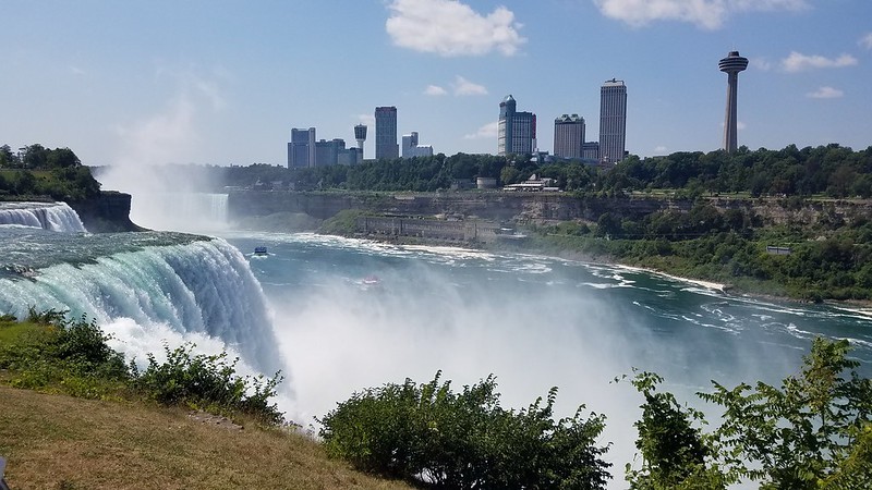
Our first full day here we drove to Niagara Falls State Park; might as well get the expected visit to the Falls out of the way. I figured visiting the Falls was a corny, touristy thing to do. Was I wrong! Looking out on the powerful falls was breathtaking. What an amazing show nature puts on for us lowly humans to enjoy.
American Falls with the mist off Bridal Veil behind it and Horseshoe Falls
Fun facts: • Three different Falls make up what we call “Niagara Falls”: The Canadian Horseshoe Falls – the largest of the falls with 90% of it in Canada; The American Falls – the second-largest; and Bridal Veil Falls – the smallest of the falls.
• Niagara Falls is at the international boundary between the US and Canada. The Niagara River is a connecting channel between two Great Lakes, Erie and Ontario.
• The source of the water that plunges over the Falls comes from four of the Great Lakes: Superior, Huron, Michigan and Erie. Once the water flows over the Falls, it travels down the Niagara River to Lake Ontario, then flows into the St. Lawrence River and finally into the Atlantic. The water flow journey takes about 15 hours.
• The Great Lakes is the world’s largest surface freshwater system in the world containing about 18% of the world’s supply. If spread out, the volume of water in the Great Lakes would cover North America in about 3.5 ft. of water.
• Why is the water so green? The startling green color of the Niagara River is a visible tribute to the erosive power of water. An estimated 60 tons of dissolved minerals are swept over Niagara Falls every minute. The color comes from the dissolved salts and very finely ground rock called ‘rock flour’.
• Less than 1% of the water in the Great Lakes is renewable, while the rest of it comes from the last ice age. (That’s some pretty old water!) The waterfalls have been pumping out water for the past 12,000 years, even as they’ve receded about 7 miles back.
After marveling at the power and beauty of the American and Bridal Veil Falls, we found a shaded table to have lunch, then drove to Goat Island. Goat Island is a small island in the Niagara River that separates the Bridal Veil Falls and the Horseshoe Falls. From Goat Island you get an up-close view of the Horseshoe Falls, so close you get rained on by the mist off the Falls.
We then headed over to the Aquarium of Niagara, a small aquarium with a big mission: to inspire people to make a difference for aquatic life. Founded in 1965 by a group of scientists and chemists, their goal was to develop and promote an artificial seawater formula specifically for inland aquariums. Their formula, Instant Ocean, is now used by most inland aquariums all over the world.
The Aquarium is a rescue facility. They accept rescued marine mammals with all sorts of conditions, from blindness to chronic seizures to missing flippers; some of the animals were injured by boat propellers and fishing equipment. The goal of their program is to give the animals a fulfilled second chance at life, while educating the public about the plights aquatic animals face and how we can work together to help. The facility is evolving into the premier facility for blind seals. All of their seals were rescued and deemed at low chance of survival if returned to their natural habitat. They also have 3 sea lions.
We arrived just in time to watch the sea lion show. It was sweet to see the animals’ relationship with their trainers – 2 young women whose affection for the sea lions was clear in their interactions. The Aquarium has a Penguin Coast exhibit with a colony of Humboldt penguins. There’s something mesmerizing about penguins, they’re so darn adorable.
After stopping at a local market for some groceries, we headed back on the Niagara Scenic Parkway, stopping at Whirlpool State Park, where you can get a close up view of the rapids of the Niagara River as it rushes through the gorge, creating a whirlpool.
Niagara River heading towards the whirlpool
After dinner we walked down to the lake shore to watch the sunset. The skies were hazy so we couldn’t get a clear view of the sun sinking below the horizon, but the pinks and oranges of the setting sun were pretty nonetheless. And you CAN see Toronto across the lake! Because of the haze we needed binoculars to get a better look, but you could see the skyline out there.
We visited the Corning Museum of Glass. Who knew you could have an entire museum devoted to glass? You can easily spend 2 days exploring all the museum has to offer. It’s an art museum, with several rooms devoted to contemporary glass art, it’s amazing what artists can do with glass as their medium; it’s a history museum documenting 3,500 years of glass making; it’s a science and technology museum, where you can learn about glass chemistry, about inventors whose ideas changed the world and all of the ways glass has influenced the way we live. There are 30 glass shows a day where you can watch glass blowers and flame workers, there are interactive exhibits, like Make Your Own Glass and more. We barely scratched the surface, spending much of our visit enjoying the art and watching a glass blower make a delicate looking pitcher and a flamethrower working on an intricate flower bouquet. We capped off our visit at the gift shop and bought a Pyrex casserole dish for the RV kitchen for only $5 and added to our set of Corelle dishes.
We drove around Seneca Lake following the Seneca Lake Wine Trail. The trail is a 37-mile drive around the entirety of the lake, with wineries offering tastings and wine cellars. Some of the wineries have cafes or restaurants with views of the lake, some had gift shops. There are more than 31 vineyards along the lake and those are just the member wineries that are highlighted on the Trail. The drive offers some gorgeous views of the lake and the hills beyond. We stopped for one tasting at the Seneca Shore Wine Cellars. For $10 you get a flight of 5 wines of your choosing; we tasted 10 wines between us, more like sips since we’re both light weight drinkers. It’s fun to taste the varieties of wine vintners produce. I tried a wine called “Kisses” that tasted like strawberries and chocolate, and enjoyed their Merlot. We stopped in Geneva at the northern tip of the Lake. Geneva is home to William and Hobart College; it seemed like a pretty place to go to school. We took a walk on the boardwalk and stopped for a snack, but the buzzing wasps were a nuisance and drove us away.
We visited the roadside waterfalls of Montour Falls. The village of Montour Falls is named for Queen Catharine Montour, a Seneca tribe leader and resident of the area. Originally named Catharine’s Town, it was the target of the Battle of Newtown of 1779, the military action aimed at driving the Iroquois nations out of the area to deprive the British of an important ally. Queen Catharine Montour’s log palace was burned down and residents of Catharine’s Town dispersed as far away as Niagara and Canada.
The Village of Montour Falls is surrounded by hills rising 1,000 feet with seven natural glens (narrow valleys) and several waterfalls. Shequaga Falls (Tumbling Waters in the Seneca language) is located at the end of Main Street, between 2 houses. Imagine having a 165-foot tall waterfall in your backyard? There’s a small park at the foot of the falls with benches and picnic tables. It’s amazing to me that you can park your car, walk maybe 50 yards and stand at the foot of a waterfall.
Down the street from Shequaga Falls is Aunt Sarah’s Falls. Apparently, the falls often dry out to a trickle, but the day we visited the falls were roaring, thanks to tropical storm Fred’s heavy rains. Who was Aunt Sarah? According to local legend, she was an Indian wife of an early settler to this area, who jumped to her death from the falls. At one time there was a rock carving of an Indian woman’s face near the base of the falls. It was reportedly destroyed by men believing that there was gold hidden behind it.
Then we drove to the Deckertown Falls on the outskirts of the village, tucked between a neighborhood and farm fields. We parked and took the short trail (manageable enough for me) to the base of the falls. Several young people were splashing and swimming in the water. Michael continued on the trail to get closer to the falls, but wasn’t able to get a good look because of the leafy trees and vantage point.
Shequaga Falls, Aunt Sarah’s Falls, Deckertown Falls
We spent Friday in the city of Ithaca. Ithaca is a city of 32,000 on the southern tip of Cayuga Lake. Home to Cornell University, Ithaca College and Tompkins-Cortland Community College it nearly doubles in size during the school year. The city’s motto “Ithaca is Gorges” derives from several deeply cut gorges, with spectacular waterfalls carved through the rolling terrain. It was Cornell’s move in day, so the city was bustling with young looking first year students and their families.
We stopped in at Cornell’s Botanic Garden. We found a shaded table tucked in behind the Welcome Center and sat and enjoyed our lunch. It was a hot, muggy day so the shade was welcomed. We walked through the Herb Garden, nicely laid out with raised stone beds filled with themed herb gardens, like Herbs of Literature, Herbs of the Ancients, Medicinal Herbs, Savory Herbs, Fragrant Herbs and Sacred Herbs. There was a lovely arbor with seating at either end. I sat on one end in the cool, damp shade while Michael took a 45-minute work call to plan for possible computer disruptions due to the coming hurricane. It was so humid that I didn’t mind the break.
Entrance to Botanic Garden, Herb Garden
Then we headed over to the Cayuga Waterfront Trail for a bike ride. An 8-mile paved trail along the southern shore of Cayuga Lake, the trail takes you past the Ithaca Farmers Market, Cornell’s Boathouse, The Hangar Theater where they were setting up an outdoor stage for their production of “Queen’s Girl in the World”, the biggest dog park either one of us had ever seen, a golf course and the US Coast Guard station in Ithaca.
After our bike ride, we drove to Buttermilk Falls State Park which takes its name from the foaming cascade formed by Buttermilk Creek as it flows down the steep valley side toward Cayuga Lake. You can see the lower falls from the parking lot. I walked along the Gorge Trail as far as I could, then perched on a stone wall as Michael continued along the trail for a better look.
The Gorge Trail, A selfie while waiting for Michael
We were hoping to grab dinner in Ithaca, but restaurants were busier than usual thanks to Move-in day. So we drove to Watkins Glen and ate at Kookalaroc’s Bar and Grill, a locals’ place with picnic tables and a guy playing keyboards and singing badly. The food was mediocre and the bugs were biting.
On Saturday we drove to Champlin Beach on Keuka Lake. Unlike the other Finger Lakes that are long and narrow (like fingers, get it?), Keuka is Y-shaped, like fingers making a peace sign or a victory sign. In the past it was referred to as the ‘Crooked Lake’. Keuka (kew-ka) means “canoe landing” in the Iroquis language and “lake with an elbow” in the Seneca language.
Calling Champlin Beach a beach is a bit of a stretch. There was no sandy area and it was more of a grassy park along the edge of the lake. We weren’t sure if there was once a stretch of sand that had been washed out by rising water or if this is what constitutes a beach in these parts. There was a small, sectioned off swimming area watched over by two lifeguards; seemed like overkill to me. I would love to see these lifeguards manage the ocean beaches of RI or Cape Cod.
We left the “beach” and drove along the western shore of Keuka Lake. The road was on the top of a hill and below the road there was a long stretch of lake houses. You could mostly just see the tops of the roofs. Many of the houses had docks. We drove across the northern tips of the 2 branches, then made our way to Seneca Lake.
On our way back we stopped at Glenora Wine Cellars, Seneca Lakes oldest winery established in 1977. Besides the winery it has a restaurant and a 30 room inn; the wine cellar is on a hill with restaurant and inn below. We bought some snacks, I ordered a glass of Wondrous Watermelon fruit wine and we sat out on the deck overlooking the lake and the vineyards beyond. Tomorrow is our last day here. It’ll be a downtime day as we ready to move onto the next leg of our trip. Lake Ontario is up next.
One of the things the early European explorers discovered in the region now called the Finger Lakes was an abundance of wild grapevines. The early European settlers of the area tried growing grapes to produce the kind of wine they had enjoyed back home. But the grape vines they planted failed to survive long enough in the Northeastern climate to bear sufficient crops. The earliest recorded attempt at growing grapes dates to 1829, when Reverend William Bostwick planted 2 kinds of grapes in the rectory garden in Hammondsport, near Keuka Lake.
In the 1950s, Ukrainian immigrant Dr. Konstantin Frank, armed with a Ph.D. in viticulture and experience in winemaking in the cool Ukrainian climate, went to work at Cornell in Ithaca; his Ph.D. thesis was on techniques for growing the common grapevine in a cold climate. He urged local winemakers to move away from native North American grapes and instead plant Vitis vinifera, (the common grapevine) the traditional grapes of European winemakers. His techniques and innovations began a wine-making revolution in the Finger Lakes.
Along with the hybrid grapes developed by Dr. Frank, the lakes themselves are responsible for the success of the vineyards. The deep lakes help to moderate the temperature. Stored heat is released from the lakes during winter, keeping the local climate mild relative to the surrounding area and helping to prevent early frost. Most of the vineyards are planted on steep hillsides overlooking the lakes, providing good drainage, better sun exposure and reduced risk of frost.
The big boon to the Finger Lakes wine industry was the passage of the New York Farm Winery Act in 1976 permitting wineries to sell directly to the public. Within 20 years of the law taking effect the number of Finger Lakes wineries grew from half a dozen to 50. As of spring 2014, there were 130 wineries and current estimates put that number at 200.
It’s Wednesday and it’s been raining all day, not just occasional rain throughout the day, but a fairly steady, drenching rain courtesy of Tropical Storm Fred. The nearby town of Addison was evacuated. It sits on Tuscarora Creek and there’s a risk of flooding.
It’s definitely an inside day, enabling Michael to work all day guilt-free. It’s given me the chance to read, do some long overdue synagogue work and write the blog post on Corning’s history. It’s a low key, productive day, but I do hope the rain stops soon.
One of the things I most enjoy about travelling is learning the history of a place. So here goes my history lesson on Corning, NY.
Corning is located in Steuben County. (Fun fact: Steuben County is bigger in size than RI.) The county was named for Baron von Steuben, a Prussian military officer who fought on the American side during the Revolutionary War. He was responsible for whipping the bedraggled Continental Army into a fighting force; we learned about him at the Valley Forge Park. “How does a ragtag volunteer army in need of a shower somehow defeat a global superpower?” (Guns and Ships/Hamilton: The Musical). The answer: Baron von Steuben.
A settlement, near today’s Corning, was founded in 1796 as a lumber town. It was named for the Albany financier and railroad executive Erastus Corning. He spearheaded the building of a railroad connecting Pennsylvania coal mines with the Chemung canal. The Chemung River, a Lenape word for “at the horn”, flows through the town. The town of Corning was established in1852.
Land Acknowlegement: The native settlers of the region were tribes of the Iroquis Nation. Corning lies on the ancestral lands of the Seneca people.
During the Revolutionary War, American forces were plagued by negative encounters with the native tribes. The Iroquois tribes were British allies. They helped British forces raid and terrorize the Continental Army and neighboring settlements.
In 1779, Washington ordered an attack on the Iroquois tribes, looking to destroy the Iroquois Nation (insert very sad and deeply disappointed emoji). This military action became known as the Battle of Newtown. After the war, Washington recognized the need to amicably settle land disputes with the Iroquois. A conference was scheduled to work out treaties with the various tribes; 5 treaties were signed. Later in 1794, the Second Treaty of Canandaigua recognized and ratified all former agreements. But, as one historian put it, “…they did not realize that millions of white people would eventually arrive and take most of their land.”
In 1868, the owner of the Brooklyn Flint Glass Works relocated his company to Corning, NY, spurred by the cheap, unlimited supply of coal, a willing work force and excellent transportation via the railroad. He changed the name of the company to Corning Flint Glass Works.
Corning, Inc., headquartered in Corning , NY for over a 150 years, has a long history of science-based innovations in glassware and ceramics. In the 1880s it worked with Thomas Edison to develop the light bulb, in the 1930s it fabricated telescope mirrors for the California Institute of Technology, in the 60s it helped create safer windshields, in the 70s it worked on the development of fiber optics. And let’s not forget Pyrex, Corningware and Corelle, all developed and manufactured by Corning, Inc.
Corning, Inc has without a doubt played an outsized role in the development of this corner of Upstate New York.
The first leg of our trip is to the Finger Lakes region of New York State. The Finger Lakes are a group of eleven long, narrow, roughly north–south flowing lakes in the central part of the state. A Native American legend claims that the lakes were formed when the Great Spirit laid its hands on the land to bless it, leaving behind finger imprints that filled with water, forming the lakes. The area also has gorges and waterfalls aplenty. The region is the biggest producer of wines in NY state, with over 120 wineries.
Our first stop was in Cobleskill, NY, about halfway to Corning. We spent the night in the parking lot at Grapevine Farms, a Harvest Host. The Farm is housed in an 1850’s farmhouse. It has three floors: a wine cellar/shop selling only NY State wines, a bistro and a gift shop. We only made it to the wine cellar for a tasting and purchased a bottle of wine and some hard cider. The farmhouse has a lovely veranda where we sat and enjoyed a glass of the wine we tasted. We chatted with the server who was warm and friendly. And we took our dinner out to the Adirondack chairs by the field. It was a pretty night, a bit overcast so no starry sky, but still a pleasant evening. Only the bugs kept us from hanging out longer.
Grapevine Farms, Cobleskill, NY
Typically, Harvest Host locations offer you a place to boondock for the night. Boondocking is camping without electric/water connections, i.e., hook-ups. Having nothing to unhook makes it easy to get an early start in the morning. Which is exactly what we did, arriving by early afternoon at our home for the next seven days – MorningStar RV Park in Corning, NY. After hooking up and eating a late lunch we headed into Watkins Glen. The village of Watkins Glen sits on the southern tip of Seneca Lake, the deepest and second longest of the Finger Lakes.
Seneca Lake
Michael associates Watkins Glen with auto racing. I associate it with music festivals. Turns out we were both right.
In 1948, a Cornell law student proposed to the Chamber of Commerce that an amateur road race be held in the village, to be named “Watkins Glen Grand Prix”. The Chamber authorized it and on October 2, 1948, 15 cars started the 8-lap, 52.8-mile race referred to as The Glen. Initially, public roads were used for the race course. In 1956 a permanent circuit for the race was built.
In 1957 NASCAR came to town, followed by the International Formula Libre in 1958. Auto racing continues in Watkins Glen and is so popular with the NASCAR community that the current track and facility is named “America’s Best NASCAR Track”.
Summer Jam was held on July 28, 1973 at the Grand Prix Racetrack in Watkins Glen. A record-breaking total of 600,000 people showed up for the festival, more than at Woodstock. At the time it earned the title of “largest audience for a pop festival” by the Guinness Book of World Records.
We drove on Route 414 and came upon Hector Falls, right along the roadside. You can pull over, park the car and walk over to the falls. The Falls are 165’ high, only 50’ of it is above the road, but it still looked fairly impressive to me.
Hector Falls
We took a a drive through town, following some of the original Grand Prix road course, then made our way to the Watkins Glen State Park. The centerpiece of the nearly 800-acre park is a 400’ gorge cut through by the Glen Creek. The Park has three trails that take you by its 19 waterfalls. The most popular trail is the 1.5-mile Gorge Trail. The beginning of the trail is paved and takes you to the first waterfalls under the Sentry Bridge. The Sentry Bridge dates back to the 1930s and was built by the Civilian Conservation Corps. Then you climb a long set of steps to get to the bridge and continue along the trail. I didn’t even try to make it past the stairs (the trail has 800 steps total), but the entrance was stunning enough for me.
Sentry Bridge
It was close to dinnertime, so we decided to look for a place to eat. We opted for The Village Marina Bar & Grill at Seneca Harbor. It has outdoor seating by the marina overlooking Seneca Lake. It was a great way to end the day.
We headed out on Sunday for our Lakes adventure, but not without last minute drama. A pattern seems to be emerging that some crisis or urgent situation comes up that has to be addressed before we leave sending us into a stressful tizzy. This trip was no different.
Aaron has a new job in Lincoln, which is a bit of a drive from his place in Newport. For the last few weeks he’s been spending a few nights with us in Providence to shorten his drive to work. It’s lovely having him with us. He is still loving and affectionate. The close proximity makes it easier to have interesting conversations where I get to hear his views and perspectives on life. I marvel at what a wonderful human being he is and am so grateful for the relationship we have.
Saturday evening while having dinner at our house Aaron got an email from his manager. She tested positive for COVID; he spent most of Wednesday’s work day with her behind the desk. Yikes! Panic ensues. He’s planning to drive to NJ the next day for the wedding of a childhood friend and Monday he has plans to visit with some college friends. And, of course, we’re leaving the next day.
He took a rapid test. Negative. But rapid tests have a 50% false negative; they’re useful if you’re positive, not so much if you’re negative. A PCR test is the gold standard, which he got Sunday morning. Aaron canceled his trip to NJ and waited for his test results.
But what do WE do? If he’s positive that means we were exposed. It’s easy enough to socially distance and even quarantine in the motorhome, but do we want to risk being sick on the road? It was a gut-wrenching evening of discussion and researching and worry and sadness for Aaron. In the end we decided to go ahead with our plans. I figured at the first sign of a symptom we would head back home.
The good news is that Aaron tested negative. He missed the wedding and the visit with his friends, but was greatly relieved that he didn’t expose anyone to this nasty virus. Phew! That’s the first time we’ve knowingly come close to possible exposure to COVID, but probably not the last.
In some ways our last day in Vermont was a good representative of the trip—Beautiful scenery with a bit of rain mixed in. We took a drive north, to Barton, VT. There is a pretty lake just outside of town. We relaxed by the water, watching the children play and some kayakers take to the water. In the distance we saw a wind farm, which produces enough energy to power 15,000 homes. We visited the bath houses, built by the Civilian Conservation Corps. After a while it started to rain, so we headed back to the RV.
Lunch, in Lyndonville
The day before we had lunch at a town park and went to a goat farm to buy goat cheese.
Mount Mansfield in Stowe, VT
We visited Stowe the other day to ride on the bike trail. After driving an hour and setting up Cathie’s trike, she rode it for 20 feet and, it stopped. I tried everything to get it going, to no avail. If this sounds familiar, yes, this same thing happened to us in Durham! It was so frustrating. We decided to split up, with Cathie exploring the town while I rode the trail. Cathie found a nice restaurant with outdoor seating and had a delicious salad. I rode the trail and enjoyed the exercise, fresh air and the scenery. There were lots of people using the trail; it’s a real treasure for the town. After I finished my ride, I called Cathie. She told me the restaurant where she was staying and I rode to meet her. Then we drove on the Toll Road for Mount Mansfield, the highest mountain in Vermont. Once we reached the top, Cathie and I explored one of the walking trails. It was too rocky and uneven for Cathie, so I forged ahead alone and was rewarded with a stunning view of western Vermont with Lake Champlain and the Adirondacks in the distance. It’s hard to see the detail in the picture above because the day was a bit hazy. Back down the mountain before heading back to the RV.
We spent a lot of time driving in and around Vermont. It’s a beautiful state, with green mountains, winding rivers and the occasional covered bridge spotted around the state. Also, there are no straight roads in Vermont. Each road seems to follow one of the many meandering rivers. Nothing seems to be close, so we drove almost every day.
Crystal Lake
We’re back home now and expect to be here for a few weeks. Then we hope to take a trip to the Great Lakes!
Eating twice in 10 miles seems a bit decadent to me. On Friday we we’re definitely decadent.
We started the day in Montpelier, at the Vermont History Museum. We both commented on the great layout of the museum. There was a lot on display in a relatively small space. Vermont abolished slavery upon its founding, in 1777, earlier than any state. We learned about the tug of war between New York and New Hampshire regarding who had the right to sell deeds of land in the area that became Vermont. New York won in court, which caused a lot of unrest in the colony. Ethan Allen helped found the Green Mountain Boys, a militia that resisted New York’s attempt to control the territory. (And you probably thought he started a furniture store!)
After the museum, we went to The Skinny Pancake, a restaurant that offers crepe sandwiches and desserts. We each had a nice sandwich on the outdoor patio, watching the bustle of downtown Montpelier.
We then headed to Waterbury, a quaint village that is in a relatively touristy area. After touring the town, we drove a few miles to a cider mill, learned about the cider-making process and snacked on cider and cider donuts. Yum.
Waterbury is also home to Ben & Jerry’s Ice Cream. We really couldn’t come this close to Ben & Jerry’s without stopping. Prior to the pandemic one could tour the factory. On Friday we instead got a chance to wait in line for half and hour before selecting our second snack of the afternoon. (I had the Butter Pecan, if you were wondering.)
I had “Change the Whirled”, a flavor honoring Colin Kaepernick’s activism and pursuit of racial justice. His portion of the proceeds go to Know Your Rights Camp…yummy and anti-racist. Cathie
At that point I felt like you could roll me down the hill. I managed to squeeze into the car for the drive home.
On Thursday we trekked across the state to Burlington. The 1.5 hour drive includes mostly secondary roads, with an interstate for the last part of the drive.
We started our day in the “People’s Republic of Burlington” by taking a bike ride along the banks of Lake Champlain. The 13 mile bike trail runs through Burlington and over a causeway onto Grand Isle, the largest island in Lake Champlain. We didn’t ride the entire trail but did manage to enjoy ourselves on the part of the trail we explored.
Lake Champlain, with the Adirondacks in the background
After the bike ride we headed downtown to Church Street for lunch. Part of Church Street has been converted to a pedestrian area, with many shops and restaurants. That’s where I snapped the picture at the top of the page.
The old St. Johnsbury train station, now a Welcome Center
St. Johnsbury is a typical Vermont town. It has a small downtown and a relaxed pace. With about 7,500 residents it’s the commercial center of Northeast Vermont. I believe there is one traffic light in the town. We walked through part of the town’s commercial district, going into a bookstore and a clothing store. I noticed how different the downtown traffic is here. The cars stop for pedestrians, even before they step into the street. At the many 4-way streets, no one rushes; it seems like everyone wants to wait for the other car to proceed through the intersection first.
Downtown St. Johnsbury
One interesting tidbit I learned is that St. Johnsbury doesn’t have a high school. Instead, students go to St. Johnsbury Academy, a private boarding and day school. The town pays the school for each town student who attends this high school. Apparently this is not unique in New England. Many private schools were established in this area before there were public schools. Some towns chose to use the private schools instead of building a public school.
Fairbanks Museum
There is an incredible little museum in town. The Fairbanks Museum was founded in 1890 by Franklin Fairbanks and houses about 175,000 natural and historical objects. This museum is a gem in itself. Notice the detailed woodwork in the pictures below, including the detail in the risers of the spiral staircase and the curved ceiling of the building.
Fairbanks Museum
The Fairbanks family included inventors, governors and other public figures. Franklin’s uncle invented the first platform scale; his father and brother were Governors of Vermont and his father was one of the founders of the Republican Party (Lincoln’s party). Franklin, along with his brother, father and uncles worked for Fairbanks Scales, the family business which made platform scales. Franklin was a collector and eventually decided to put his collections into a museum.
The museum includes a butterfly garden. While we visited the garden, one of the residents, a Tiger Swallowtail, decided to climb up my leg. It crawled up to my shoulder blades before flying off.
We spent the day exploring the byways of Vermont yesterday. We started by taking a lovely drive on US Highway 5, down the Connecticut River Valley. Some stretches of the road were empty of traffic, due to the nearby interstate road that most locals use to get anywhere. We stopped in Norwich, home of the King Arthur Baking Company, where we had a snack. If you are a baker, you probably have heard of them. If not, this company has been making flour and other baking goods since 1790. At the store we picked up some provisions. I bought some Rye flour, hoping to make Rye bread someday.
Back on the road we headed west and north, following another, smaller river through Vermont. It seemed that every road we take in Vermont (except interstates) follows a river. There is usually a beautiful view just a few miles down the road. We stopped at Quechee Gorge, a spectacular gorge right off the highway. The name, Quechee, comes from the Natick Indian tribe’s river name, Ottauquechee, meaning swift mountain stream. Well, it certainly is a swift stream!
Quechee GorgeThe dam at the top of Quechee Gorge
We didn’t get back to the campsite until almost 8pm. Fortunately we had some leftovers in the fridge for dinner.
Montpelier prides itself on being small: “Montpelier has the distinction of being the smallest state capital in the United States, with a population of just over 8,000 people.” There are no McDonald’s restaurants in the city. The city park is a rugged park with gravel roads. It’s the quirky town that you would expect to be the capital of Vermont.
Cathie and I spent much of the day yesterday in Montpelier. We drove around the city to get a sense of it. We walked around the two streets that make up the downtown. We had lunch outside at a nice Mexican restaurant, watching people walk by. We drove into Hubbard Park. It was a nice day. We plan to go back to explore a bit further.
On Thursday we took a bike ride on the Lemoille Valley Rail Trail. This trail runs on the bed of the railroad that joined St. Johnsbury to Montpelier and Lake Ontario to Portland Maine. The trail is planned to eventually be the longest in New England, covering 93 miles. Currently 34 miles are finished. We didn’t go that far, though. We started in St. Johnsbury and rode about 6 miles, uphill, through the woods. There were very few signs of civilization, just an occasional house or two near the trail. Route 2 wasn’t too far away; we heard it at points on the ride. Otherwise it was a wonderful ride. Riding back was a breeze. I coasted almost the entire way, pedaling only once or twice until the end.
It’s our first night at Moose River Campground, in St. Johnsbury, Vermont. We had an eventful few days but we arrived here without any major mishaps.
Over the past few days we’ve had a tire incident, a dental complication and missing keys. Last Saturday while taking some items to the RV, we ran over a pothole and punctured the tire. It took close to an hour for AAA to come and change it. Unfortunately, I wasn’t able to change the tire because the wrench that came with the car didn’t fit the lug nuts. Fun. Saturday was also the day that Cathie couldn’t find her set of keys for the RV. She looked everywhere in the house but no luck. On Monday I had a crown put on my tooth but found out that the night guard I wear didn’t fit over the crown. The only appointment I could get to replace it was 8:15am on Wednesday in Chepachet, about 40 minutes from the house. This was on the day we planned to leave for Vermont.
Slowly, things came together. On Monday, Cathie went to the locksmith and was able to get replacements for all three keys. On Tuesday, she dropped the car at the tire shop and they fixed the tire. And the appointment this morning went fine and I was back in Providence at a reasonable time.
The drive up was mostly boring, with some rain just as we were driving through Franconia Notch, making the drive more entertaining that I would like. By the time we arrived, the sun had come out and it was very pleasant. We set up the RV, unpacked and settled in. After dinner we took a walk around the campground. It’s a small park, with only 45 sites. The Moose River, more like a creek, runs alongside the park.
The Moose River
We are staying here for two weeks. This will give us a chance to do some exploring and time to just chill. We are looking forward to it.
It was a good day. It was supposed to rain this morning but as we packed up, the sun peeked through the clouds. We got a reasonably good start, leaving the campground before 9:15. Traffic was OK and the weather cooperated. We got to the storage facility before 3:00 and were home and unpacked before 5:00.
Shortly after we got home, I got a call from our son, Aaron. He wanted to know if we were home and could he stop over. So, we got a Welcome Home from our favorite son! Aaron had just come from a job interview at his rock climbing gym to teach summer youth classes. He was very confident about the job; they actually sent him a job offer while we were talking.
It was a good trip. We had some hiccups but nothing serious. (Our water leak problem was finally solved after I cleaned out the water pump filter. No more leaks!!) We were able to visit several family members and we saw some incredible natural beauty. We’re both happy to be in our house for a few weeks and are already looking forward to our next trip. Stay tuned!
We got up early on Tuesday, ready for a travel day. After packing up and hooking up the car, we set off to the Hudson Valley. We planned one more night on the road. This stop would position us so we didn’t have a killer day driving back to the storage facility and then having to drive home.
When we got here, we set up camp. I muttered to myself that it took so much time to set up and we were just going to have to pack up in the morning. I came into the RV and Cathie asked, “Why did we decide to spend just one night here?” Clearly both of us were on the same wavelength. I went up to the office and requested another night. So, we’re here for two nights. Whew!
We had a simple dinner tonight that we ate outside in the screen tent. I stayed here to enjoy the pleasant weather. Right now it’s about 8 PM and I’m listening to the birds talking to each other. There is a beautiful stand of pine trees on my right, dark green against the blue sky. I hear and see some geese, honking as they fly by. It’s wonderful to be alive.