OK, I’m sold. Michigan is a beautiful state with some incredible natural wonders. Today we spent most of the day at Sleeping Bear Dunes National Lakeshore. This gem is in the northwest corner of the lower peninsula. The park stretches 35 miles along Lake Michigan and contains forests, dunes, beaches, islands and remnants of ancient glacial activity. The name of the park comes from an Ojibwa legend. As described in a Wikipedia article:
According to the legend, an enormous forest fire on the western shore of Lake Michigan drove a mother bear and her two cubs into the lake for shelter, determined to reach the opposite shore. After many miles of swimming, the two cubs lagged behind. When the mother bear reached the shore, she waited on the top of a high bluff. The exhausted cubs drowned in the lake, but the mother bear stayed and waited in hopes that her cubs would finally appear. Impressed by the mother bear’s determination and faith, the Great Spirit created two islands (North and South Manitou islands) to commemorate the cubs, and the winds buried the sleeping bear under the sands of the dunes where she waits to this day.
One of the highlights of the park is the Dune Climb. It’s a 3.6 mile hike up several dunes, through the windblown sand. It’s not an easy hike but I was rewarded with spectacular views. Cathie stayed below while I explored the trail.
The Dune Climb Trail
Today was a windy, autumn day. The waves reminded me of beaches on the Atlantic Ocean, complete with whitecaps. We originally planned to have lunch outdoors but decided to snack on our sandwiches in the car, due to the wind.
Lake Michigan at Glen Haven Historical Area
The park includes a 7.4 mile roadway through the varied terrain of the park. The drive was designed and built by Pierce Stocking, a lumberman who worked for the Civilian Conservation Corps before becoming a lumberman. He loved the beauty of the dunes so much that he wanted to share his love with others. The drive opened in 1967. After Pierce Stocking’s death in 1976, the roadway became part of the Sleeping Bear Dunes National Lakeshore. We spent over an hour driving and stopping at various points on the roadway, viewing stunning vistas.
Lake Michigan view from Pierce Stocking Drive
We ended our day in Frankfort, a cute town a bit south of the park, along the Lake Michigan coast. We decided to have dinner at a local restaurant so that we could view the sunset over the lake.
On Monday (9/20) we made our way to Traverse City. We’re staying at the Holiday Park RV Campground. It’s a lovely campground on the shore of Silver Lake in Traverse City. This is home for the next 6 nights.
Traverse City is in northwestern Michigan. It has a population of about 15,000. The city lies at the base of two bays, East Grand Traverse Bay and West Grand Traverse Bay, which flow into the Grand Traverse Bay which then empties into Lake Michigan. Separating the bays is a narrow peninsula heading north from Traverse City called Old Mission Peninsula. “La Grand Traverse” was the name given to this body of water by French traders because of the “long crossing” they had to make by canoe across the mouth of the bay.
After dinner we took a drive into town. We stopped at the waterfront with its marina. Then drove through the downtown area and made the obligatory stop at The Cherry Republic store which sells all things cherry; Traverse City is the cherry capital of the world. It looks like a charming city.
Tuesday was a rainy day. I didn’t mind though because it was a work day for Michael. I did laundry – we were overdue – paid some bills and did other odds and ends. Tomorrow we set out to start exploring.
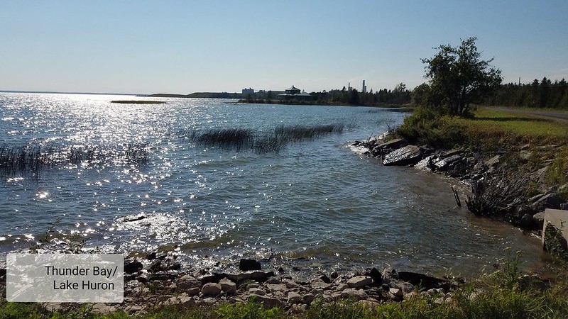
It’s hard to see a sunset over Lake Huron in Northern Michigan. The lake is on the eastern side of the state, so, sunrises but not sunsets. But Cathie found a place. We went to Rogers City today for dinner and a sunset view. The park where these pictures are taken is a small cove where we were able to see the sun set over the water. However we got a bonus treat with an ‘almost’ full moonrise as well. The pictures don’t do the scene justice.
We took a bike ride into Hillman today. The RV park where we’re staying, The Thunder Bay Golf and RV Resort (no, we don’t play golf and yes, it’s an odd combination) is in the town of Hillman, 23 miles west of Alpena. Hillman has a population of 638. It’s a one street town.
We can bike into town from the campsite. A bridge takes us over the Thunder Bay River, behind the elementary school and connects up with the Hillman Bike Path. Such a nice surprise to find that a tiny town has a bike path.
Thunder Bay River/Autumn is coming to Hillman
Small town insurance agency and small town Post Office
What does it say about a place that hangs art in its restrooms and decorates its stalls with inspirational quotes?
Ladies room at Besser Museum for Northeast Michigan
Ladies room stall
The Besser Museum, in addition to it’s natural history exhibits, had a small modern art gallery.
A Picasso and a DaliSegol Sher Shalosh by Yaacov Agam. Born n 1928 in then Mandate Palestine, studied at the Bezalel Academy in Jerusalem.
There’s an historically-oriented walking tour along the Thunder Bay River in downtown Alpena. The goal of the River Walk is to demonstrate the importance of Lake Huron and the Thunder Bay River in the development of Alpena and its unique maritime culture and to share its history.
Alpena Heritage Riverwalk along Thunder Bay River
Informational plaque on the Riverwalk about the Fire of 1888
There are several parks in Alpena on Huron Bay. All have beaches, some with playgrounds, some with picnic tables. We stopped at Mich-E-Ke-wis Park, named in honor of Chief Mich-E-Ke-Wis, one of the last Native American chiefs in the area. His name means “Spirit of the Western Wind”. He lived to be nearly 110 years old. He died in 1857
Traveling across the state of Michigan is very different from traveling across the state of Rhode Island. Michigan is the 22nd largest state in the US. It’s slightly smaller than all six New England states combined. You could fit Rhode Island into it 54 times and still have something left over. So, the climate in Michigan varies more than within each of the New England states. The other day we were in Bay City, about 120 miles south of our current location, near Alpena. The leaves were looking a bit washed out but hadn’t started turning yet. Here, some of the trees are starting to turn. Even though Friday was over 80 degrees, fall is coming.
On Friday we went into Alpena, about 20 miles from our campground. It’s a town with a lot of history. There was a large lumber industry in Northern Michigan in the 1800’s. By the early 1900’s Alpena started developing an industrial base, with the Besser Company, maker of concrete blocks, and other manufacturing. Today tourism also accounts for a significant portion of the economy.
Cathie and I toured the area, went to the Besser History museum and visited one of many beaches in town. We capped off the day at an outdoor restaurant in town.
Tuesday (9/14) was our last full day in the Bay City area before heading north. We drove to Saginaw, a city of 49,000 people, about 20 miles south of Bay City. The early residents of the area were the Sauk and Chippewa tribes. Saginaw means ‘land of the Sauks’. The first permanent non-Native settlement was in 1816 with the establishment of a fur-trading post on the banks of the Saginaw River. By the mid-1800s Saginaw, dubbed the lumber capital of the world, became a thriving lumber town as the country’s expansion west resulted in increasing demand for lumber. The forests in most of Michigan are of white pine trees, good for construction and boat building lumber.
Our first stop was the Shiawassee National Wildlife Refuge. The refuge is almost 10,000 acres of forest, marsh and wetlands. It has a 6-mile auto drive tour; there was a posted list of what to do on the drive to increase your chances of seeing wildlife. I was so excited. Since I can’t hike, I don’t usually get the chance to get deep into nature. So I was deeply disappointed when we arrived at the start of the drive to find the gate closed. If I had bothered to go to the website, I would have known that the drive is closed until next June for restoration work. We had to settle for a short walk on a hiking trail and a view from an observation deck.
It was time for lunch so we looked for a park. We settled on Celebration Park, right in downtown Saginaw. The weather was sunny and warm and I was aware that we soon won’t have these beautiful summer days to enjoy. I’m not looking forward to another Covid winter.
After lunch we headed to the Castle Museum. Housed in the former Post Office, the building does indeed look like a castle with a main tower and several turrets. Built in 1898, the architect was inspired by the early French settlement of the area. By the 1930s the city needed a bigger post office and the Federal government planned construction of a new building on the same site. But there was such strong opposition to tearing down the landmark that the plan shifted to enlarging the existing building. In 1970, the building again faced demolition. At that time the Saginaw County government responded by buying the building to preserve it and the building eventually became the Castle Museum.
One of the exhibits was set up as the post office with some of the original equipment and included the observation area – 2 flights up to a narrow passage with small openings along both walls where supervisors could surreptitiously observe the postal workers at work. Creepy. As Michael said, thank goodness for unions. Although my understanding is that today’s postal workers are still closely monitored.
There was an interesting exhibit on Saginaw’s attempt to break into the fledgling automotive industry. At the start of the 1900s, the community of Saginaw was looking for a replacement for the lumber industry to create jobs and a stable economy. Several companies tried their hand at breaking into the brand-new automotive industry. The Saginaw Cyclecar was one of the cars designed and built and sold in 1914; 35 of them were built. One of them, apple red in color, was on display at the museum. In 2014, a Cyclecar was restored to working order. It was taken out for a ride by a couple dressed in period clothes. A short video was filmed of the excursion and was part of the exhibit. You can watch the video here:
Another exhibit covered the history of The Pit and Balcony theater group. Started in 1932, it was made up of seven members who met in each other’s homes to read and act plays. By the second year the group had grown to 200 members. A local resident offered the use of their property and the group began performing in what was referred to as the Barn. When the theater outgrew its space the group launched a campaign to raise money to build it’s own theater. In the fall of 1949, the first play in the new building was produced. The Pit and Balcony Theatre is still in operation and offers a full season of shows.
Another exhibit explored the stories of Saginaw’s silver screens. Saginaw, which in the late 1800s was Michigan’s third largest city, showed its first movie in 1897, two years after the process of projecting moving images onto a screen was invented. It was home to several movie houses in the 20s and 30s. The exhibit featured a wonderful collection of old movie posters.
Historic Movie Posters
It was an interesting museum and a demonstration of the pride the community takes in its history.
One difference I’ve noticed between New England and the Midwest is the number of trains and train tracks. In Ohio and Michigan, we often saw train tracks running through a town. When a train runs through those towns they disrupt the traffic. That seldom happens in New England. There is typically a bridge over the tracks so the train doesn’t affect auto traffic. We have heard trains at almost every campground where we stayed. At the campground in Corning, NY the train went right behind the campground. Even at the last campground, which in a rural area, we sometimes heard a train horn blowing. Well, today we got closer to the train experience. As we were driving the RV out of town, we were stopped by a train crossing the road. It took about 5 minutes for the train to pass.
We are now in Hillman, Michigan. The terrain is different here with small hills in the area and evergreen trees around the campground. We have clearly left the marshland and farmland of the Saginaw Bay Area.
One point on Saginaw Bay: We noticed so many waterfowl during our time there. Cranes, egrets and other waterfowl were very common.
If you don’t know your Michigan geography, that’s fine. I didn’t either until we traveled here. Michigan consists of two parts, the Lower Peninsula, or the main part of Michigan and the Upper Peninsula, commonly called the UP. Geographically, when you look at the Lower Peninsula, it looks like the back of the left hand covered in a mitten. Michiganers use the hand reference, describing The Mitt and The Thumb to clarify where something is located.
Today we explored part of the Thumb. We drove up the western side of the Thumb, which borders Saginaw Bay, up to the Port Austin area, which is at the top. The road went mostly through farmland but we did notice two interesting items. One was the Michigan Sugar plant in Sebewaing. This company makes sugar from beets and produces about 1.1 billion pounds of sugar annually. The other item was a large wind farm. We thought it was large but didn’t realize how large until we looked it up. Currently there are 836 turbines producing 1584 MW of electricity.
The weather went from cloudy to sunny and back to cloudy. Before it started raining, we had a chance to visit a butterfly garden and have lunch outdoors.
On our first full day here we went into Bay City, the closest city to the Finn Road Campground in Essexville where we’re staying. It has a population of about 35,000 people. The Saginaw River flows through the middle of the city; 4 drawbridge make it possible to travel around the city. Our first stop was the Bay County Riverwalk trail for a bike ride.
It was a perfect weather day, sunny and in the 70’s. The Trail is an 18-mile loop through woodlands and marshes, a couple of city parks, neighborhoods and Bay City center. We didn’t do the full 18 miles, but the section we covered was varied and lovely. We biked along marshes, home to a variety of water birds. We saw lots of cranes and egrets and a whole range of ducks and geese. (Unfortunately I left my phone in the car and didn’t get any pictures. ) We saw one of the drawbridges open for a passing sailboat. We could see the Bay City skyline. Bay City has an amphitheater called theWorld Friendship Shell that opened in 2020. They were getting ready for a weekend musical festival and we got to hear their sound check.
Back at the car we had our lunch at a nearby picnic table before heading into town. We took a stroll through the downtown area. A couple of blocks are closed to traffic and all of the restaurants have outdoor patios set up. The place was busy with lots of diners. We drove through some of the Bay City neighborhoods, including the historic district along Center Avenue with beautiful old houses built by the Bay City ship builders, lumbermen and industrialists who made their fortunes in the mid 1800s.
It was time to think about dinner so we headed back to downtown and decided on a restaurant called the ‘MI Table’. We had to wait an hour for an outside table, but that gave us the chance to sit on a bench and people watch. The MI Table serves ‘Michigan cuisine’, highlighting Michigan produce, fish and game. I briefly considered trying the Elk meatballs, but decided on BBQ cauliflower instead and I skipped the Venison Stir Fry and settled on Chicken Pot Pie. Michael had a Fresh White Fish sandwich, not to be confused with the typical Jewish whitefish salad. And I’m not sure how it fits with Michigan cuisine, but they had a selection of bubble teas. The Strawberry Coconut Bubble Tea was very yummy.
Summer is over. The hot weather we had just a couple of weeks ago in northern New York is gone, replaced with a hint of Fall. Yesterday we planned a bike ride in Jackson, but after a picnic lunch in a park we decided that the blustery day wasn’t right for a bike ride. Instead, we went to a vineyard in the area and had a pleasant snack outdoors, overlooking the vineyard. Last night, we needed the heavier blanket as the temperature went below 50 degrees overnight.
Today we drove up to Saginaw Bay. We’ll be staying here for a few days. The weather is a bit warmer today and hopefully tomorrow as well. We expect to be in Michigan for a few weeks, exploring Lake Huron on the eastern side of the state and Lake Michigan on the western side. We won’t get to Lake Superior in the north, though.
Interesting fact: Although Michigan has over 11,000 lakes, it’s not the state with the most lakes. Alaska holds that honor with over 3 million lakes, most of them unnamed. Minnesota, known as the land of 10,000 lakes, is second and Wisconsin is third. Michigan does border the most number of Great Lakes, though. In addition to Lake Huron, Lake Michigan and Lake Superior, it also borders Lake Erie in the southeastern corner of the state.
Tashlich is a ritual practiced on the first day of Rosh Hashanah. From the Hebrew word for “casting off”, it’s a practice of gathering at a body of water, enumerating your sins of the past year out loud and symbolically “casting” them off by tossing pebbles or bread crumbs into the water.
Our congregation has held a tashlich ceremony at the Duck Pond in Attleboro on the afternoon of Rosh Hashanah for as long as I can remember. Last year, as this year, we were traveling during the holidays and couldn’t join in. Thanks to the miracle of the internet, we have been able to participate in High Holiday services which have been online because of Covid.
This year we were able to join with the Ann Arbor Reconstructionist Congregation for their tashlich service. Thank you Rabbi Ora Nitkin-Kaner for graciously welcoming us in. The weather forecast was predicting thunderstorms, so we weren’t sure if tashlich would even happen. But the weather held and it wasn’t until we were driving back that the downpour started with streaks of lighting filling the sky. It’s still raining and thundering as I write this.
Mallet Creek (that tiny white speck in the middle of the picture is a crane)
We’ll be spending the next 3 or so weeks making our way through Michigan. After the overnight stop in Dundee, MI we landed at the Hideaway Campground (yes, another Hideaway) in Grass Lake, MI. Grass Lake is 50 miles east of Lansing, about 65 miles west of Detroit and near Ann Arbor. It’s a smallish campground, quiet and very friendly – everybody waves at you. Our site is at the back with a wooded area behind us. We’ll be celebrating the Jewish New Year here.
We arrived in Grass Lake on Saturday. On Sunday we drove into Detroit. The city of Detroit lies on the Detroit River, the international border between the US and Canada. Windsor, Ontario is 1.8 miles across the river from Detroit. The river is 28 miles long, flowing west and south from Lake Huron and Lake St. Clair to Lake Erie. (Fun Fact: Lake St. Clair, part of the Great Lakes water system is sometimes considered the sixth Great Lake, although it’s much smaller than the other five).
Detroit River with Windsor in the background
In the 60s, the Detroit River, one of the busiest waterways in the world, was so polluted it was considered “dead” (unable to support aquatic life). In 1970 the entire fishing industry of the river was shut down due to high levels of mercury. In 1972 an agreement was made between the US and Canada “to protect, restore and enhance the Detroit River ecosystem”. Today the river is healthy and an economic boon to the area: bird watching and photography, recreational boating, river cruises and dinner cruises, fishing and waterfowl hunting, marinas, and restaurants with boat docks are just some of the activities that draw people to the River.
The Detroit RiverWalk was our first stop. What a fabulous place! There are parks, plazas, a sandy beach, walking paths, bike trails, lots of green spaces with orange Adirondack chairs placed throughout. There’s a big playground that’s essentially an oversized sand box. There’s the 6,000 seat Aretha Franklin Amphitheater with a full schedule of shows, an outdoor adventure center, beautiful gardens with pieces of urban art and more.
We found free parking near Valade Park. The Park has a big plaza set up with tables and umbrellas. It was sunny and in the 80s, so the umbrellas were welcomed. The Park has a structure called the Shed, that’s used for food, events and programming. On Sundays they have the Sunday Brunch Market where local vendors set up their wares, including 3 restaurants serving food. We ordered Kimchi Curly Fries from a place called Geisha Girls. What an interesting combination of flavors, so yummy.
Valade Park
We enjoyed our fries and lunch under an umbrella and watched the many people out enjoying the lovely weather and the view of the River. There was such a lively vibe and energy, so different from what I think of when I think of Detroit. Then we strolled along the walkway and again I regretted not bringing the bikes. My Trike was in the car and in retrospect I wish we had pulled it out. We could have experienced so much more of the RiverWalk if I’d had the help of the Trike. Maybe someday I’ll remember in time to use it.
Next we drove to Belle Isle Park, a 987-acre island park in the Detroit River. It’s another wonderful recreational resource with beaches, picnic pavilions, an aquarium, the Great Lakes Museum, athletic fields, tennis courts, boat and bike rentals, and even a zoo. It offers spectacular views of the Detroit and Windsor skyline. And it was in heavy use, with large gatherings of family and friends barbecuing and enjoying the beach
Belle Isle Park
We took a quick drive through Detroit. I had read about the 8 Mile Wall, a 6′ high wall built in 1941 to segregate two neighborhoods on the north side of Detroit and I needed to see it for myself.
In the 1940s a developer wanted to build a community nearby exclusively for whites. But banks weren’t issuing loans in majority black neighborhoods – the practice known as red-lining modeled on the Federal Housing Administration’s policies. The FHA’s reasoning was that racially mixed areas were likely to stir confrontation, leading to violence and creating a “hazardous” neighborhood.
To get a federally backed loan, the developer approached the FHA a second time and proposed building a six-foot high, one-foot-thick wall. The Agency agreed and the Birchwood Wall was built, separating the black neighborhood on the east side from the new “white” neighborhood on the west side. The wall still stands, covered in painted murals, as an urban art exhibit and a lesson in institutionalized racism.
“Through the 1920’s and 30’s as [Detroit] continued to grow, what was once rural farmland on the outer edges of the city was rapidly consumed by housing developments, financed in part by housing loans by the Federal Housing Authority. But there was a catch – the FHA would often not offer or guarantee loans in neighborhoods that were considered “undesirable” or “distressed” – code words for neighborhoods with significant numbers of blacks or Jews. Without these loans, Wyoming and 8 Mile remained relatively undeveloped… the [eventual] wall would be mostly symbolic…but it would make clear that on one side blacks would not be welcome to build or live. This was enough to satisfy the FHA, which approved the loans, and the housing development was built.” (excerpted from Detroiturbex.com)
We only caught glimpses of the wall between houses, but it was still a stunning thing to see.
We stopped for a night in Dundee, MI, a cute little town northwest of Toledo and southwest of Detroit. We are staying at a retreat center, that welcomes overnight guests. The retreat center, Riverside Retreat, was founded by a couple who wanted to have a retreat center in the area. It offers various programs and activities as well as a retreat for pastors. It’s on the outskirts of the town with pretty grounds and a peaceful river rolling past the back yard.
Grist Mill turned into museum
Dundee feels like small town America. There is clearly pride in this town, with the banners welcoming you to ‘Historic Dundee’. A museum is housed in a former grist mill. There are nice walkways around the River Raisin, which flows through the town. All is good here. Except…
House built in 1851
This area was formerly the home of the Potawatomi tribe. The history of the tribe is a sad but typical story of loss experienced by many Native American tribes in the US. The US recognized the Potawatomi as a single tribe, even though they were decentralized with tribal leaders in each geographic area. After the Revolutionary War, white settlers started moving into the area. The US government created a reservation in the area, Macon Reservation, for the Potawatomi tribe in 1807. By the time the War of 1812 occurred, the tribal leaders decided that they would be better off with the British. They joined the war on the British side and fought some successful battles against the US. After the war, the British stopped alliances with the Potawatomi. Things went further downhill from there for the tribe. Slowly but surely the US government chopped off portions of the land allocated for the reservation. By 1830 the reservation was eliminated; the tribe was forced to move west. Some left, some remained, some went to Canada.
It’s still a cute town, if you don’t think about its history too much.
In addition to missing out on seeing the RBG exhibit at The Maltz, I was disappointed that The Hubbard House Underground Railroad Museum in Ashtabula was only offering scheduled tours (thanks Covid) and that all the tours were booked for the season. The museum is housed in the former William and Katharine Hubbard Homestead. Hubbard was a staunch abolitionist and joined the local Anti-Slavery Society soon after settling in Ashtabula.
The house was an important stop on the Underground Railroad, the network of homes abolitionists used to transport slaves into the 14 free states and Canada. Close to Lake Erie, The Hubbard Homestead – code named “Mother Hubbard’s Cupboard” – was strategically located and was often the last stop for fugitive slaves before they crossed the Lake to Canada.
Ashtabula County’s network was an instrumental part of the Railroad system with over thirty known “stations”. Penalties for escaping slaves and those who helped them were severe, so secrecy was paramount. Railroad terms were used as code: the enslaved persons were “freight” or “cargo”; the person taking slaves from station to station was the “conductor”; the hiding places were “depots”; “agents” were sympathizers who helped the enslaved person connect with the Railroad, and so on.
There were Underground Railroad networks throughout the country, but Ohio’s was the most extensive network of any other state with about 3000 miles of routes used by escaping runaways. Why Ohio? Ohio was bordered by 2 slave states, Virginia and Kentucky, and of all the states involved in the Railroad it was the closest to Canada, with only 250 miles or less from anywhere along the Ohio River to Lake Erie and freedom. Ohio also had a large Quaker population. While the Pennsylvania Quakers were largely responsible for starting the abolitionist movement, the Ohio Quakers were more directly involved in actually moving escaping enslaved individuals.
I’m sure I would have enjoyed the museum; all the reviews I read were positive. But now it’s on to Michigan, with stops along Lake Huron and Lake Michigan.
Our campsite. Notice the ‘neighborhood’ in the background.
One of the benefits of traveling is that you get a sense of how others live. We just spent several days in the northeastern part of Ohio. Ashtabula is not a happy town. There doesn’t seem to be a lot of joy in this area. There are no fun spots for locals or tourists. The sound of trains are a constant here. We’re camping a few miles from the ‘downtown’ part of the city yet we constantly hear the horns of trains passing through, on their way to or from the Northeast.
The campground where we are staying is primarily for ‘seasonals’, people who spend the entire season at the campground. I suspect that some are year-round residents of this campground, judging by the amount of firewood next to their campers. The campground is actually pretty, with several ponds and lots of trees. People are friendly as well. But I have the feeling that we are staying in someone’s neighborhood, rather than a campground.
‘Campsites’ at Ashtabula campground
The weather has shifted. A week ago we were battling the heat of the summer. Days in Wilson, NY were in the 80’s and nights didn’t get much below 70. This morning when we woke up it was in the 50’s. Cathie wondered if we should get the heavier blanket out for tonight. It’s refreshing but also a warning that cool weather, and winter is coming. As if to punctuate Nature’s message to us, one type of tree in this area is starting to shed its leaves.
Today we are off to Michigan. We will likely spend several weeks in Michigan, exploring Lake Huron and Lake Michigan. The state also touches a third Great Lake, Superior. We decided that going up that far is a bit too much for this trip. The Upper Peninsula of Michigan, which borders Lake Superior has some great natural beauty, with lots of hiking trails. But there isn’t much for Cathie to do there and it would make the trip much longer.
Today we visited Cleveland. We spent most of our time in the suburb of Beachwood. About 90% of Beachwood’s population identifies as Jewish. The city has the 4th largest per capita Jewish population of any municipality outside of Israel, surpassed only by a town in Azerbaijan whose entire population is Jewish, a town in NY that’s home to a Satmar Hasidic sect and a town in NJ with mostly Sephardic Orthodox Jews mainly from Syria.
Beachwood’s Jewish establishment is rooted in decades of development of various Jewish institutions, such as synagogues, Jewish schools, an assisted living facility, a health center, a huge JCC, with a preschool, day camp, swim club, athletic facility and more, Cleveland’s Jewish Federation, The Maltz Museum of Jewish Heritage, as well as stores and other businesses. Beachwood’s Jewish community is also reflected in the city’s public schools, with Hebrew being offered as a foreign language at the local Middle and High School, making Beachwood one of the only public schools in the US to have Hebrew as part of its language curriculum.
Our first stop was The Maltz Museum. Michael figured it would be a quick stop, maybe an hour-long. But the museum was impressive and extensive. It detailed the history of Jews in greater Cleveland against the backdrop of Jewish world history. It has 2 permanent exhibits, “An American Story” chronicling the challenges and achievements of Northeast Ohio’s Jewish communities, first established in the 1800s by European Jewish settlers and “The Temple-Tifereth Israel Gallery” focused on tradition and ritual. There are also 5 special exhibits, one of them on the golden age of comics, spotlighting Superman, the original superhero created by 2 Clevelanders. I was disappointed that we just missed a special exhibit on RBG. It closed 2 days earlier and was in the process of being packed up for its next stop in NYC.
It was time for lunch, so we headed to an Israeli deli called Arova. I had a very yummy pastrami sandwich in pita with fried onions and Israeli pickles and Michael had a loaded falafel sandwich with amba sauce, an Israeli condiment, and declared it the best falafel sandwich he’d eaten outside of Israel.
We drove into Cleveland and stopped at a waterfront park to admire Lake Erie against the backdrop of the Cleveland skyline. We walked down to a paved walkway right along the shoreline. The lake was stirred up with waves washing over the walkway. We had to step back or risk getting wet. Two men sat casually fishing. I was struck by the juxtaposition of the expanse of the lake and the big city, not something we see in New England or even the Northeast.
Lake Erie against the Cleveland skyline
We drove through downtown Cleveland by the Case Western Reserve campus, several hospitals, the Natural History Museum, the very interesting Museum of Contemporary Art building, an unusual shiny black 6-sided building (at first, I couldn’t figure out what it was) and along the Cultural Gardens, a collection of city gardens commemorating the various ethnic groups that make up Cleveland.
There was so much we could have explored in the city but it was time to head back.
We headed to Erie for the day. Our first stop was Presque Isle, a sandy peninsula jutting into Lake Erie. The neck of the peninsula is attached to the mainland, 4 miles west of downtown Erie. The sandy land mass, called a sandspit, was formed in the most recent glacial period, 11,000 years ago. Declared a state park in 1921, Presque Isle State Park has 3,112-acres of lakefront nature. The park has 13 miles of roads, 21 miles of recreational trails, 13 beaches for swimming, and a marina. It’s Pennsylvania’s only “seashore”. We debated bringing the bikes and decided against it. When I saw how gorgeous the park was I regretted our decision. I wish we had an extra day to spend just biking the isle.
Lake Erie, Beach 7 on Presque Isle
The beaches on Presque Isle are numbered. We stopped at Beach 7 for lunch. A family consisting of 2 grandparents with their 2 granddaughters were enjoying the beach. I loved watching the grand dad playing with one of the kids in the lake, until a lifeguard waved them in closer to shore.
There’s an inlet on the bay side of the Isle called Horseshoe Pond with an interesting history dating back to the 1890s. In that era, many immigrants, mostly Russian and Slovak, couldn’t afford regular houses, so they just built shacks that also floated.
In the early 1920s, the Park and Harbor Commission, which was then in charge of Presque Isle State Park, realized they had a severe problem with the houseboats. Because they were all over the bay, and usually in terrible condition, arguments and problems between the owners and the commission were ongoing. The Commission decided to limit the number of houseboats and contain them to Horseshoe Pond. Today 24 houseboats serve as summer homes to its owners.
House boats in Horseshoe Pond
We drove around the park, stopping to marvel at the houseboats, then drove on to stop at one of the lighthouses. The Tom Ridge Environmental Center is located at the entrance of the park. We were hoping to stop in to learn more about the Isle’s diverse ecosystem, but realized we didn’t have time to explore the Center before it closed for the day.
We headed back to the campground through the city of Erie and onto Geneva-on- the-Lake, Ohio, a resort village in the northeast corner of Ashtabula county on Lake Erie. The main road through the village is called “the Strip”, and is lined with parks, restaurants, arcades, and ice cream and candy shops and has been a tourist attraction for decades. It had a Jersey Shore feel to it, touristy and a little too tacky for me.
We stopped for dinner at Luisa’s Mexican Grill in Geneva proper, right on the main street. Across the street was a store front that took up the entire block with the name ‘Griffiths’ in big letters across the top. Griffith’s Furniture and Appliances was a family-owned business that clearly had a significant role in the town. Now it sits empty. I always feel a little sad in these areas that were once popular and full of life, but now are mostly empty and a little run down.
This week is Lake Erie week. We’re staying in Ashtabula, OH in the Hide-a-way Lakes Campground. Lake Erie is the shallowest and the fourth largest of the 5 Great Lakes (Ontario is the smallest). It has the reputation of being the “killer lake” due to severe and sudden storms that can quickly kick up waves.
Ashtabula County is in the northeast corner of Ohio along the shore of Lake Erie, about halfway between Cleveland, OH and Erie, PA. It covers 26 miles of Lake Erie shoreline. The Iroquois people, the Six Nations, called the area home. The Northwest Indian War (1785-1795) was mounted to push out the indigenous settlers of the region, enabling Europeans to move in.
The area was first settled by Europeans in 1801; its name, most likely of Algonquian origin, probably means “river of many fish” (that’s a lot of maybes). In the early 1800s, Ashtabula County was the first county created in the Western Reserve. Beginning in the late 19th century, Ashtabula became a major coal port on Lake Erie at the mouth of the Ashtabula River northeast of Cleveland.
What the heck is the Western Reserve? That’s the question I asked myself and I quickly realized how little I know about Colonial history. As I sort of jokingly told Michael, I know about the Mayflower and I know about the Boston Tea Party and the Revolutionary War and I don’t know much about the 150ish years in between. So I set out to learn a little bit about Colonial America to help me understand about the Western Reserve. Here’s some of what I’ve learned.
As the English settled the Eastern seaboard of the “New World”, charters were granted by the British Crown giving colonies the legal right to exist and outlining the relationship between the colony and the Crown. There were 3 kinds of charters. One, simply called a Charter, was granted to businesses (Connecticut, Massachusetts and Rhode Island). Royal charters granted a colony legal status but continued to be governed by the British government (New Hampshire, New York, New Jersey, North and South Carolina, Georgia). Proprietary charters were granted to an individual or family (Delaware, Maryland, Pennsylvania). As part of their charters, colonies would often claim land beyond their immediate area.
The colony of Connecticut laid claim to a large portion of what is now Northern Ohio, extending westward with no limit and named it the Connecticut Western Reserve. The Connecticut Land Company sent General Moses Cleaveland to survey the land and lay out townships. One of the earliest towns was named for the surveyor. Originally called Cleaveland, a map maker’s ‘typo’ resulted in the new spelling of Cleveland and that’s how it’s been spelled since the 1820s. The area’s accessibility to Lake Erie drew many New Englanders to the Reserve. Following the Revolutionary War, Connecticut gave up its claim to the Western Reserve in exchange for the new Federal government assuming its war debts.
The term Western Reserve is still used in the area – the Western Reserve Land Conservancy, Western Reserve Academy, some public schools have the term in their name (Western Reserve Middle School in Collins, OH), the Western Reserve school district, etc.
Probably the most widely known (the one I was familiar with) is Case Western Reserve University. Starting out as Western Reserve college, founded in 1826, as with most (maybe all) of the early educational institutions like Harvard, Yale, Princeton… the purpose of the school was to train young men for the clergy. Several school mergers later, Case Western Reserve University was established in 1969, the final merger between Western Reserve University and Case Institute of Technology.
In the 19th century, the Western Reserve region was probably the most fervent anti-slavery area in the country leading to Ohio’s prominent role in the abolitionist movement and the Underground Railroad. Another piece of Ohio and Lake Erie history to learn about…
SATURDAY Today was the nicest weather day we’ve had here, although still too hot for me. There was less humidity, so it didn’t feel as oppressive. It was in the low 80s, with mostly blue skies. There was a breeze, making it tolerable in the shade. It’s our last day here. Tomorrow we move on to Ashtabula, OH, on Lake Erie.
We drove to Lockport today, about 16 miles southeast of Wilson. The history of Lockport is tied to the building of the Erie Canal. The Canal was built between 1817 and 1825, eventually creating a waterway connecting the Hudson River, near Albany to the Niagara River, near Buffalo onto Lake Erie. The Erie Canal transformed New York City into a major port, supplanting Boston and Philadelphia.
To reach Lake Erie, the Canal designers and builders had to solve the challenge of what’s called the Niagara Escarpment, a geological feature between Rochester and Buffalo, where the land rises sharply over a rocky ridge. Their design solution was to build a “staircase” named the Flight of Five, that would lift or lower a canal boat in 5 steps. The Flight of Five Locks (5 locks going west, 5 locks going east) was built in what became Lockport.
We visited the Erie Canal Discovery Center, a small but informative museum on the history of the Erie Canal and how it created Lockport. There was a model of the Flight of Five locks and a short video illustrating the 5 locks in action. The Center is located near the locks, offering more information about the Canal and locks.
The parking lot for the Center was near a lovely square in downtown Lockport where the local Farmer’s Market is held. Before heading into the Discovery Center, we walked through the stalls, coming away with some fresh produce, including free kale given to us by the farmers who didn’t want to take it back with them.
After our visit to the Center, we drove to a nearby park to eat lunch, then over to the Erie Canalway Trail for a bike ride along the Canal.
Biking along the Erie Canal
Yesterday we took a bike ride on the Two Mile Creek Greenway section of the Shoreline Trail that follows the Niagara River. The bike path took us through the Isle View Park, a pretty park that clearly gets a lot of use. There were lots of folks sitting by the water, some having picnics. There were boats and water skiers on the river. There was even a wedding in progress. The Park has a gazebo, boat launch pads, a playground and even had a pretty garden called The Tribute Garden honoring lives affected by domestic violence. The Park is a lovely community resource.